Amares geodata
Amares (Braga) is a seat of a second-order administrative division; located in Portugal in Europe/Lisbon (GMT+1) time zone. In our database, there are 824 cities with bigger population. Compared to other cities in Portugal, 96.4% of cities are located further ↓South; 66% of cities are located further ←West and 55.1% of cities have higher elevation than Amares. Note1


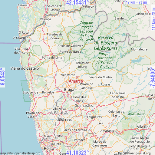
Amares GPS coordinates[2]
41° 37' 51.276" North, 8° 21' 4.212" West
| Map corner | latitude | longitude |
|---|---|---|
| Upper-left | 42.15431°, | -9.0543° |
| Center: | 41.63091°, | -8.35117° |
| Lower-right: | 41.10323°, | -7.64805° |
| Map W x H: | 116.9×116.9 km | = 72.6×72.6mi |
| max Lat: | 42.11337° ⇑3.6% North |
| Amares: | 41.63091° |
| min Lat: | ⇓96.4% South 32.6448° |
| min Long | Amares | max Long |
| -31.17847° | -8.35117° | -6.27308° |
| W 66%⇐ | ⇒34% E |
Elevation
Elevation of Amares is 92 m = 302 ft, and this is 85 m = 279 ft below average elevation for this country.
| Max E: |
1008 m = 3307 ft | 55.1% |
| Avg. | 177 m = 581 ft | |
| Amares | 92 m = 302 ft | |
Min E: |
-128 m = -420 ft | 44.9% |
See also: Portugal elevation on elevation.city.
Geographical zone
Amares is located in North temperate zone (between Tropic of Cancer and the Arctic Circle). Distance of this Northern Tropic circle is 2023 km =1257 mi to South.| Distance of | km | miles | from Amares |
|---|---|---|---|
| North Pole | 5378.1 | 3341.8 | to North |
| Arctic Circle | 2772.3 | 1722.6 | to North |
| Tropic Cancer | 2023 | 1257 | to South |
| Equator | 4628.9 | 2876.3 | to South |


Nearby cities:
15 places around Amares: (largest is in red/bold)
• Adaúfe
6.2 km =3.9 mi,  218°
218°
• Braga
10.6 km =6.6 mi,  212°
212°
• Caldelas
5.1 km =3.2 mi,  330°
330°
• Ferreiros
1 km =0.6 mi,  270°
270°
• Frossos
11 km =6.8 mi,  229°
229°
• Goães
4.7 km =2.9 mi,  48°
48°
• Lago
5.2 km =3.2 mi,  258°
258°
• Merelim
10.8 km =6.7 mi,  242°
242°
• Prado
9.8 km =6.1 mi,  251°
251°
• Póvoa de Lanhoso
9.1 km =5.7 mi,  132°
132°
• Real
11.1 km =6.9 mi, 223°
• Rendufe
4.8 km =3 mi, 267°
• Sande
8.6 km =5.3 mi,  336°
336°
• Terras de Bouro
10.3 km =6.4 mi,  20°
20°
• Vila Verde
7.4 km =4.6 mi,  284°
284°
Sources, notices
• [Note1] Compared only with cities in Portugal existing in our database
• [Src1] Map data: © OpenStreetMap contributors (CC-BY-SA)
• [Src2] Other city data from geonames.org with taken over terms of usage.
• [Src3] Geographical zone / Annual Mean Temperature by Robert A. Rohde @ Wikipedia
