Fornos de Algodres geodata
Fornos de Algodres (Guarda) is a seat of a second-order administrative division; located in Portugal in Europe/Lisbon (GMT+1) time zone. In our database, there are 824 cities with bigger population. Compared to other cities in Portugal, 63.6% of cities are located further ↓South; 91% of cities are located further ←West and 96.7% of cities have lower elevation than Fornos de Algodres. Note1


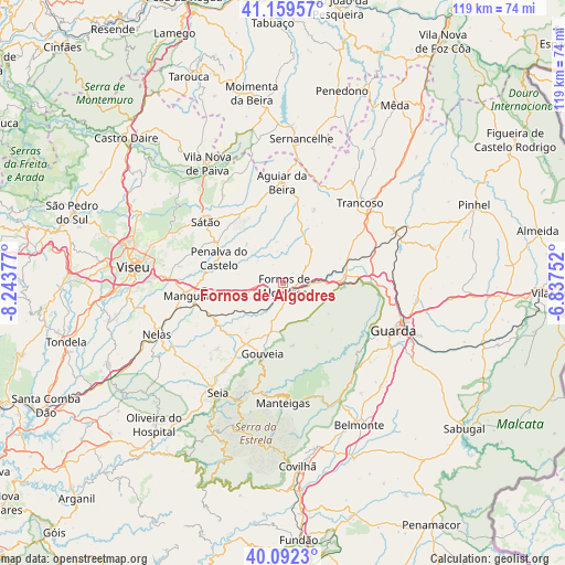
Fornos de Algodres GPS coordinates[2]
40° 37' 41.052" North, 7° 32' 26.304" West
| Map corner | latitude | longitude |
|---|---|---|
| Upper-left | 41.15957°, | -8.24377° |
| Center: | 40.62807°, | -7.54064° |
| Lower-right: | 40.0923°, | -6.83752° |
| Map W x H: | 118.7×118.7 km | = 73.8×73.8mi |
| max Lat: | 42.11337° ⇑36.4% North |
| Fornos de Algodres: | 40.62807° |
| min Lat: | ⇓63.6% South 32.6448° |
| min Long | Fornos de Algod | max Long |
| -31.17847° | -7.54064° | -6.27308° |
| W 91%⇐ | ⇒9% E |
Elevation
Elevation of Fornos de Algodres is 677 m = 2221 ft, and this is 500 m = 1640 ft above average elevation for this country.
| Max E: |
1008 m = 3307 ft | 3.3% |
| Fornos de Algodres | 677 m 2221 ft | |
| Avg. | 177 m = 581 ft | |
Min E: |
-128 m = -420 ft | 96.7% |
See also: Portugal elevation on elevation.city.
Geographical zone
Fornos de Algodres is located in North temperate zone (between Tropic of Cancer and the Arctic Circle). Distance of this Northern Tropic circle is 1911.5 km =1187.8 mi to South.| Distance of | km | miles | from Fornos de Algodres |
|---|---|---|---|
| North Pole | 5489.6 | 3411.1 | to North |
| Arctic Circle | 2883.8 | 1791.9 | to North |
| Tropic Cancer | 1911.5 | 1187.8 | to South |
| Equator | 4517.4 | 2807 | to South |


Nearby cities:
15 places around Fornos de Algodres: (largest is in red/bold)
• Aguiar da Beira
21 km =13 mi,  359°
359°
• Celorico da Beira
12.7 km =7.9 mi,  85°
85°
• Famalicão
24.8 km =15.4 mi,  146°
146°
• Guarda
25.3 km =15.7 mi,  113°
113°
• Mangualde
18.8 km =11.7 mi,  261°
261°
• Manteigas
25 km =15.5 mi,  179°
179°
• Mesquitela
18 km =11.2 mi,  254°
254°
• Nelas
28.3 km =17.6 mi, 247°
• Rio de Loba
28.8 km =17.9 mi,  278°
278°
• Seia
27.6 km =17.1 mi,  210°
210°
• Sequeira
27.8 km =17.3 mi, 107°
• Sátão
20.6 km =12.8 mi,  307°
307°
• São Romão
29.2 km =18.1 mi, 210°
• Trancoso
23.6 km =14.7 mi,  42°
42°
• Vila Nova de Paiva
29.6 km =18.4 mi,  327°
327°
Sources, notices
• [Note1] Compared only with cities in Portugal existing in our database
• [Src1] Map data: © OpenStreetMap contributors (CC-BY-SA)
• [Src2] Other city data from geonames.org with taken over terms of usage.
• [Src3] Geographical zone / Annual Mean Temperature by Robert A. Rohde @ Wikipedia
