Guarda geodata
Guarda is a seat of a first-order administrative division; located in Portugal in Europe/Lisbon (GMT+1) time zone. With population of 32,111 people, there are 46 cities with bigger population in this country. Compared to other cities in Portugal, 61.9% of cities are located further ↓South; 96.9% of cities are located further ←West and 100% of cities have lower elevation than Guarda. Note1


Guarda GPS coordinates[2]
40° 32' 14.388" North, 7° 15' 56.7" West
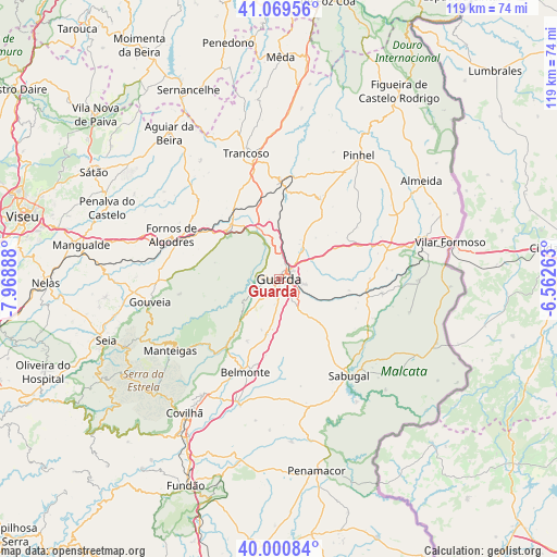
| Map corner | latitude | longitude |
|---|---|---|
| Upper-left | 41.06956°, | -7.96888° |
| Center: | 40.53733°, | -7.26575° |
| Lower-right: | 40.00084°, | -6.56263° |
| Map W x H: | 118.8×118.8 km | = 73.8×73.8mi |
| max Lat: | 42.11337° ⇑38.1% North |
| Guarda: | 40.53733° |
| min Lat: | ⇓61.9% South 32.6448° |
| min Long | Guarda | max Long |
| -31.17847° | -7.26575° | -6.27308° |
| W 96.9%⇐ | ⇒3.1% E |
Elevation
Elevation of Guarda is 1008 m = 3307 ft, and this is 831 m = 2726 ft above average elevation for this country.
| Max E: |
1008 m = 3307 ft | 0% |
| Guarda | 1008 m 3307 ft | |
| Avg. | 177 m = 581 ft | |
Min E: |
-128 m = -420 ft | 100% |
See also: Portugal elevation on elevation.city.
Geographical zone
Guarda is located in North temperate zone (between Tropic of Cancer and the Arctic Circle). Distance of this Northern Tropic circle is 1901.4 km =1181.5 mi to South.| Distance of | km | miles | from Guarda |
|---|---|---|---|
| North Pole | 5499.7 | 3417.4 | to North |
| Arctic Circle | 2893.8 | 1798.1 | to North |
| Tropic Cancer | 1901.4 | 1181.5 | to South |
| Equator | 4507.3 | 2800.7 | to South |


Nearby cities:
15 places around Guarda: (largest is in red/bold)
• Aguiar da Beira
39 km =24.2 mi,  322°
322°
• Belmonte
21 km =13 mi,  199°
199°
• Celorico da Beira
15.3 km =9.5 mi, 316°
• Covilhã
35 km =21.7 mi,  215°
215°
• Famalicão
14.1 km =8.8 mi, 222°
• Fornos de Algodres
25.3 km =15.7 mi,  293°
293°
• Manteigas
27.6 km =17.1 mi,  237°
237°
• Mesquitela
41 km =25.5 mi,  277°
277°
• Pinhel
31.2 km =19.4 mi,  32°
32°
• Sabugal
25.4 km =15.8 mi,  144°
144°
• Seia
39.8 km =24.7 mi,  250°
250°
• Sequeira
3.8 km =2.4 mi,  61°
61°
• São Romão
40.9 km =25.4 mi, 248°
• Teixoso
29.6 km =18.4 mi,  213°
213°
• Trancoso
28.3 km =17.6 mi,  345°
345°
Sources, notices
• [Note1] Compared only with cities in Portugal existing in our database
• [Src1] Map data: © OpenStreetMap contributors (CC-BY-SA)
• [Src2] Other city data from geonames.org with taken over terms of usage.
• [Src3] Geographical zone / Annual Mean Temperature by Robert A. Rohde @ Wikipedia
