Sequeira geodata
Sequeira (Guarda) is a populated place; located in Portugal in Europe/Lisbon (GMT+1) time zone. With population of 28,502 people, there are 57 cities with bigger population in this country. Compared to other cities in Portugal, 62.1% of cities are located further ↓South; 97.3% of cities are located further ←West and 99.4% of cities have lower elevation than Sequeira. Note1


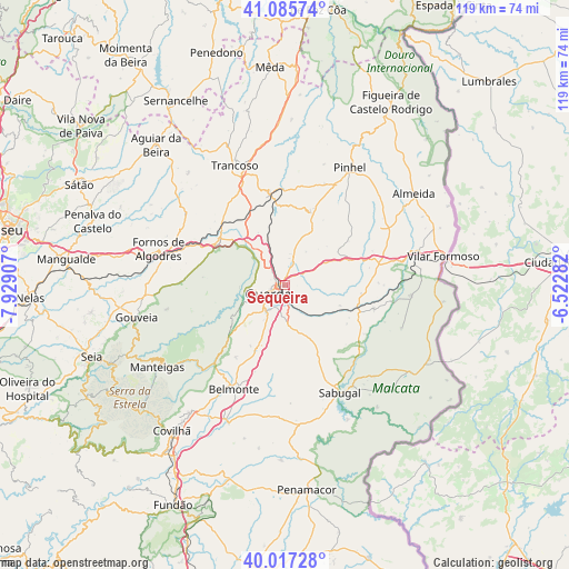
Sequeira GPS coordinates[2]
40° 33' 13.104" North, 7° 13' 33.384" West
| Map corner | latitude | longitude |
|---|---|---|
| Upper-left | 41.08574°, | -7.92907° |
| Center: | 40.55364°, | -7.22594° |
| Lower-right: | 40.01728°, | -6.52282° |
| Map W x H: | 118.8×118.8 km | = 73.8×73.8mi |
| max Lat: | 42.11337° ⇑37.9% North |
| Sequeira: | 40.55364° |
| min Lat: | ⇓62.1% South 32.6448° |
| min Long | Sequeira | max Long |
| -31.17847° | -7.22594° | -6.27308° |
| W 97.3%⇐ | ⇒2.7% E |
Elevation
Elevation of Sequeira is 853 m = 2799 ft, and this is 676 m = 2218 ft above average elevation for this country.
| Max E: |
1008 m = 3307 ft | 0.59999999999999% |
| Sequeira | 853 m 2799 ft | |
| Avg. | 177 m = 581 ft | |
Min E: |
-128 m = -420 ft | 99.4% |
See also: Portugal elevation on elevation.city.
Geographical zone
Sequeira is located in North temperate zone (between Tropic of Cancer and the Arctic Circle). Distance of this Northern Tropic circle is 1903.2 km =1182.6 mi to South.| Distance of | km | miles | from Sequeira |
|---|---|---|---|
| North Pole | 5497.9 | 3416.2 | to North |
| Arctic Circle | 2892 | 1797 | to North |
| Tropic Cancer | 1903.2 | 1182.6 | to South |
| Equator | 4509.1 | 2801.8 | to South |


Nearby cities:
15 places around Sequeira: (largest is in red/bold)
• Aguiar da Beira
39.7 km =24.7 mi,  317°
317°
• Belmonte
24 km =14.9 mi,  205°
205°
• Celorico da Beira
16.7 km =10.4 mi,  303°
303°
• Covilhã
38.4 km =23.9 mi,  217°
217°
• Famalicão
17.8 km =11.1 mi,  226°
226°
• Figueira de Castelo Rodrigo
43.7 km =27.2 mi,  30°
30°
• Fornos de Algodres
27.8 km =17.3 mi,  287°
287°
• Guarda
3.8 km =2.4 mi,  241°
241°
• Manteigas
31.4 km =19.5 mi, 237°
• Penamacor
43 km =26.7 mi,  173°
173°
• Pinhel
27.9 km =17.3 mi, 28°
• Sabugal
25.2 km =15.7 mi,  153°
153°
• Seia
43.6 km =27.1 mi,  249°
249°
• Teixoso
33 km =20.5 mi, 216°
• Trancoso
27.6 km =17.1 mi,  337°
337°
Sources, notices
• [Note1] Compared only with cities in Portugal existing in our database
• [Src1] Map data: © OpenStreetMap contributors (CC-BY-SA)
• [Src2] Other city data from geonames.org with taken over terms of usage.
• [Src3] Geographical zone / Annual Mean Temperature by Robert A. Rohde @ Wikipedia
