Pinhão geodata
Pinhão (Vila Real) is a populated place; located in Portugal in Europe/Lisbon (GMT+1) time zone. With population of 648 people, there are 802 cities with bigger population in this country. Compared to other cities in Portugal, 78.1% of cities are located further ↓South; 90.7% of cities are located further ←West and 57% of cities have higher elevation than Pinhão. Note1


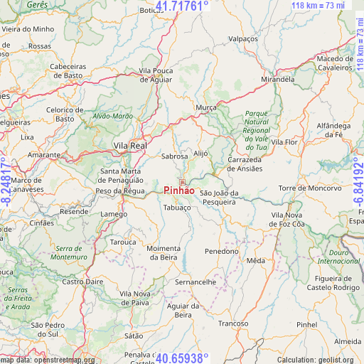
Pinhão GPS coordinates[2]
41° 11' 26.268" North, 7° 32' 42.144" West
| Map corner | latitude | longitude |
|---|---|---|
| Upper-left | 41.71761°, | -8.24817° |
| Center: | 41.19063°, | -7.54504° |
| Lower-right: | 40.65938°, | -6.84192° |
| Map W x H: | 117.7×117.7 km | = 73.1×73.1mi |
| max Lat: | 42.11337° ⇑21.9% North |
| Pinhão: | 41.19063° |
| min Lat: | ⇓78.1% South 32.6448° |
| min Long | Pinhão | max Long |
| -31.17847° | -7.54504° | -6.27308° |
| W 90.7%⇐ | ⇒9.3% E |
Elevation
Elevation of Pinhão is 87 m = 285 ft, and this is 90 m = 295 ft below average elevation for this country.
| Max E: |
1008 m = 3307 ft | 57% |
| Avg. | 177 m = 581 ft | |
| Pinhão | 87 m = 285 ft | |
Min E: |
-128 m = -420 ft | 43% |
See also: Portugal elevation on elevation.city.
Geographical zone
Pinhão is located in North temperate zone (between Tropic of Cancer and the Arctic Circle). Distance of this Northern Tropic circle is 1974 km =1226.6 mi to South.| Distance of | km | miles | from Pinhão |
|---|---|---|---|
| North Pole | 5427.1 | 3372.2 | to North |
| Arctic Circle | 2821.2 | 1753 | to North |
| Tropic Cancer | 1974 | 1226.6 | to South |
| Equator | 4580 | 2845.9 | to South |


Nearby cities:
15 places around Pinhão: (largest is in red/bold)
• Alijó
11.2 km =7 mi,  31°
31°
• Armamar
15.3 km =9.5 mi,  233°
233°
• Carrazeda de Anciães
20.7 km =12.9 mi,  73°
73°
• Custoias
21 km =13 mi,  116°
116°
• Ervedosa do Douro
6.6 km =4.1 mi,  114°
114°
• Favaios
9.3 km =5.8 mi,  21°
21°
• Fontelo
17.4 km =10.8 mi,  243°
243°
• Peso da Régua
20.5 km =12.7 mi,  261°
261°
• Sabrosa
8.9 km =5.5 mi,  343°
343°
• Santa Marta de Penaguião
20.1 km =12.5 mi,  276°
276°
• São João da Pesqueira
12.6 km =7.8 mi, 111°
• Tabuaço
8.5 km =5.3 mi,  193°
193°
• Trevões
15.3 km =9.5 mi,  142°
142°
• Vila Real
20.7 km =12.9 mi,  306°
306°
• Vilela
6.2 km =3.9 mi, 308°
Sources, notices
• [Note1] Compared only with cities in Portugal existing in our database
• [Src1] Map data: © OpenStreetMap contributors (CC-BY-SA)
• [Src2] Other city data from geonames.org with taken over terms of usage.
• [Src3] Geographical zone / Annual Mean Temperature by Robert A. Rohde @ Wikipedia
