Vilela geodata
Vilela (Vila Real) is a populated place; located in Portugal in Europe/Lisbon (GMT+1) time zone. With population of 5,540 people, there are 391 cities with bigger population in this country. Compared to other cities in Portugal, 80.4% of cities are located further ↓South; 89.7% of cities are located further ←West and 97.7% of cities have lower elevation than Vilela. Note1


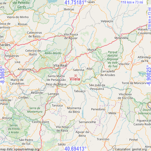
Vilela GPS coordinates[2]
41° 13' 30.396" North, 7° 36' 12.168" West
| Map corner | latitude | longitude |
|---|---|---|
| Upper-left | 41.75181°, | -8.3065° |
| Center: | 41.22511°, | -7.60338° |
| Lower-right: | 40.69413°, | -6.90025° |
| Map W x H: | 117.6×117.6 km | = 73.1×73.1mi |
| max Lat: | 42.11337° ⇑19.6% North |
| Vilela: | 41.22511° |
| min Lat: | ⇓80.4% South 32.6448° |
| min Long | Vilela | max Long |
| -31.17847° | -7.60338° | -6.27308° |
| W 89.7%⇐ | ⇒10.3% E |
Elevation
Elevation of Vilela is 712 m = 2336 ft, and this is 535 m = 1755 ft above average elevation for this country.
| Max E: |
1008 m = 3307 ft | 2.3% |
| Vilela | 712 m 2336 ft | |
| Avg. | 177 m = 581 ft | |
Min E: |
-128 m = -420 ft | 97.7% |
See also: Portugal elevation on elevation.city.
Geographical zone
Vilela is located in North temperate zone (between Tropic of Cancer and the Arctic Circle). Distance of this Northern Tropic circle is 1977.9 km =1229 mi to South.| Distance of | km | miles | from Vilela |
|---|---|---|---|
| North Pole | 5423.3 | 3369.9 | to North |
| Arctic Circle | 2817.4 | 1750.7 | to North |
| Tropic Cancer | 1977.9 | 1229 | to South |
| Equator | 4583.8 | 2848.2 | to South |


Nearby cities:
15 places around Vilela: (largest is in red/bold)
• Alijó
12.2 km =7.6 mi,  62°
62°
• Armamar
15 km =9.3 mi,  209°
209°
• Ervedosa do Douro
12.7 km =7.9 mi,  120°
120°
• Favaios
9.6 km =6 mi, 59°
• Fontelo
15.8 km =9.8 mi,  222°
222°
• Godim
17.8 km =11.1 mi,  250°
250°
• Lamego
22.4 km =13.9 mi,  230°
230°
• Peso da Régua
16.8 km =10.4 mi, 246°
• Pinhão
6.2 km =3.9 mi,  128°
128°
• Sabrosa
5.2 km =3.2 mi,  26°
26°
• Santa Marta de Penaguião
15.2 km =9.4 mi,  263°
263°
• São João da Pesqueira
18.7 km =11.6 mi, 117°
• Tabuaço
12.5 km =7.8 mi,  166°
166°
• Trevões
21.3 km =13.2 mi,  138°
138°
• Vila Real
14.5 km =9 mi,  305°
305°
Sources, notices
• [Note1] Compared only with cities in Portugal existing in our database
• [Src1] Map data: © OpenStreetMap contributors (CC-BY-SA)
• [Src2] Other city data from geonames.org with taken over terms of usage.
• [Src3] Geographical zone / Annual Mean Temperature by Robert A. Rohde @ Wikipedia
