Alijó geodata
Alijó (Vila Real) is a populated place; located in Portugal in Europe/Lisbon (GMT+1) time zone. With population of 11,942 people, there are 172 cities with bigger population in this country. Compared to other cities in Portugal, 82.7% of cities are located further ↓South; 92.8% of cities are located further ←West and 94.5% of cities have lower elevation than Alijó. Note1


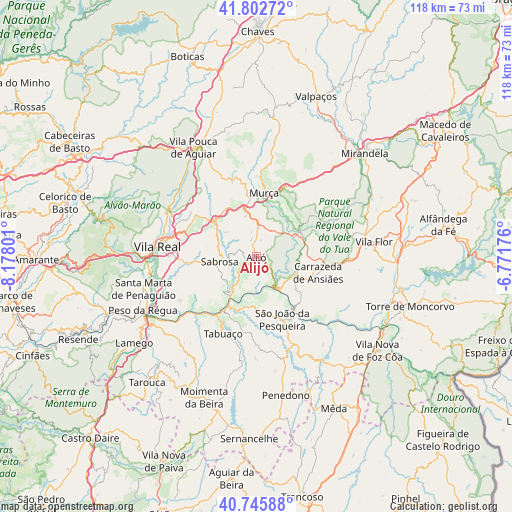
Alijó GPS coordinates[2]
41° 16' 35.184" North, 7° 28' 29.604" West
| Map corner | latitude | longitude |
|---|---|---|
| Upper-left | 41.80272°, | -8.17801° |
| Center: | 41.27644°, | -7.47489° |
| Lower-right: | 40.74588°, | -6.77176° |
| Map W x H: | 117.5×117.5 km | = 73×73mi |
| max Lat: | 42.11337° ⇑17.3% North |
| Alijó: | 41.27644° |
| min Lat: | ⇓82.7% South 32.6448° |
| min Long | Alijó | max Long |
| -31.17847° | -7.47489° | -6.27308° |
| W 92.8%⇐ | ⇒7.2% E |
Elevation
Elevation of Alijó is 578 m = 1896 ft, and this is 401 m = 1316 ft above average elevation for this country.
| Max E: |
1008 m = 3307 ft | 5.5% |
| Alijó | 578 m 1896 ft | |
| Avg. | 177 m = 581 ft | |
Min E: |
-128 m = -420 ft | 94.5% |
See also: Portugal elevation on elevation.city.
Geographical zone
Alijó is located in North temperate zone (between Tropic of Cancer and the Arctic Circle). Distance of this Northern Tropic circle is 1983.6 km =1232.6 mi to South.| Distance of | km | miles | from Alijó |
|---|---|---|---|
| North Pole | 5417.6 | 3366.3 | to North |
| Arctic Circle | 2811.7 | 1747.1 | to North |
| Tropic Cancer | 1983.6 | 1232.6 | to South |
| Equator | 4589.5 | 2851.8 | to South |


Nearby cities:
15 places around Alijó: (largest is in red/bold)
• Armamar
26.1 km =16.2 mi,  223°
223°
• Belver
16.9 km =10.5 mi,  101°
101°
• Carrazeda de Anciães
14.5 km =9 mi,  105°
105°
• Custoias
23 km =14.3 mi,  145°
145°
• Ervedosa do Douro
12.3 km =7.6 mi,  179°
179°
• Favaios
2.6 km =1.6 mi,  251°
251°
• Murça
14.5 km =9 mi,  6°
6°
• Pinhão
11.2 km =7 mi,  211°
211°
• Sabrosa
8.5 km =5.3 mi,  262°
262°
• Santa Marta de Penaguião
26.9 km =16.7 mi, 254°
• São João da Pesqueira
15.4 km =9.6 mi,  157°
157°
• Tabuaço
19.4 km =12.1 mi,  203°
203°
• Trevões
22 km =13.7 mi,  171°
171°
• Vila Real
22.7 km =14.1 mi,  276°
276°
• Vilela
12.2 km =7.6 mi,  242°
242°
Sources, notices
• [Note1] Compared only with cities in Portugal existing in our database
• [Src1] Map data: © OpenStreetMap contributors (CC-BY-SA)
• [Src2] Other city data from geonames.org with taken over terms of usage.
• [Src3] Geographical zone / Annual Mean Temperature by Robert A. Rohde @ Wikipedia
