Vila Real geodata
Vila Real is a seat of a first-order administrative division; located in Portugal in Europe/Lisbon (GMT+1) time zone. With population of 17,001 people, there are 126 cities with bigger population in this country. Compared to other cities in Portugal, 83.6% of cities are located further ↓South; 87% of cities are located further ←West and 89.7% of cities have lower elevation than Vila Real. Note1


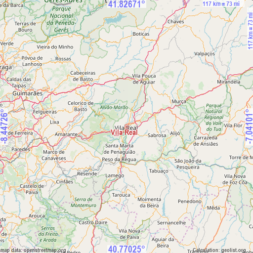
Vila Real GPS coordinates[2]
41° 18' 2.232" North, 7° 44' 38.868" West
| Map corner | latitude | longitude |
|---|---|---|
| Upper-left | 41.82671°, | -8.44726° |
| Center: | 41.30062°, | -7.74413° |
| Lower-right: | 40.77025°, | -7.04101° |
| Map W x H: | 117.5×117.5 km | = 73×73mi |
| max Lat: | 42.11337° ⇑16.4% North |
| Vila Real: | 41.30062° |
| min Lat: | ⇓83.6% South 32.6448° |
| min Long | Vila Real | max Long |
| -31.17847° | -7.74413° | -6.27308° |
| W 87%⇐ | ⇒13% E |
Elevation
Elevation of Vila Real is 462 m = 1516 ft, and this is 285 m = 935 ft above average elevation for this country.
| Max E: |
1008 m = 3307 ft | 10.3% |
| Vila Real | 462 m 1516 ft | |
| Avg. | 177 m = 581 ft | |
Min E: |
-128 m = -420 ft | 89.7% |
See also: Portugal elevation on elevation.city.
Geographical zone
Vila Real is located in North temperate zone (between Tropic of Cancer and the Arctic Circle). Distance of this Northern Tropic circle is 1986.3 km =1234.2 mi to South.| Distance of | km | miles | from Vila Real |
|---|---|---|---|
| North Pole | 5414.9 | 3364.7 | to North |
| Arctic Circle | 2809 | 1745.4 | to North |
| Tropic Cancer | 1986.3 | 1234.2 | to South |
| Equator | 4592.2 | 2853.5 | to South |


Nearby cities:
15 places around Vila Real: (largest is in red/bold)
• Alijó
22.7 km =14.1 mi,  96°
96°
• Armamar
21.9 km =13.6 mi,  168°
168°
• Celorico de Basto
23.5 km =14.6 mi,  294°
294°
• Favaios
20.3 km =12.6 mi, 100°
• Fontelo
20.2 km =12.6 mi,  176°
176°
• Godim
15.2 km =9.4 mi,  198°
198°
• Lamego
23.3 km =14.5 mi,  193°
193°
• Mesão Frio
19.8 km =12.3 mi,  217°
217°
• Mondim de Basto
21.5 km =13.4 mi,  305°
305°
• Peso da Régua
15.5 km =9.6 mi, 193°
• Pinhão
20.7 km =12.9 mi,  126°
126°
• Sabrosa
14.5 km =9 mi, 104°
• Santa Marta de Penaguião
10.6 km =6.6 mi, 198°
• Vila Pouca de Aguiar
23.7 km =14.7 mi,  20°
20°
• Vilela
14.5 km =9 mi, 125°
Sources, notices
• [Note1] Compared only with cities in Portugal existing in our database
• [Src1] Map data: © OpenStreetMap contributors (CC-BY-SA)
• [Src2] Other city data from geonames.org with taken over terms of usage.
• [Src3] Geographical zone / Annual Mean Temperature by Robert A. Rohde @ Wikipedia
