Favaios geodata
Favaios (Vila Real) is a populated place; located in Portugal in Europe/Lisbon (GMT+1) time zone. With population of 1,064 people, there are 741 cities with bigger population in this country. Compared to other cities in Portugal, 82.5% of cities are located further ↓South; 92% of cities are located further ←West and 95.9% of cities have lower elevation than Favaios. Note1


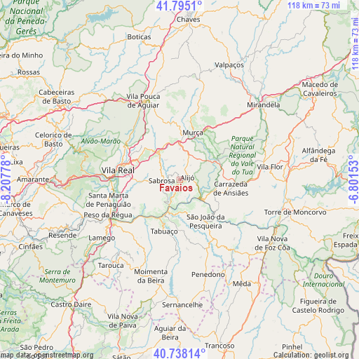
Favaios GPS coordinates[2]
41° 16' 7.536" North, 7° 30' 16.74" West
| Map corner | latitude | longitude |
|---|---|---|
| Upper-left | 41.7951°, | -8.20778° |
| Center: | 41.26876°, | -7.50465° |
| Lower-right: | 40.73814°, | -6.80153° |
| Map W x H: | 117.5×117.5 km | = 73×73mi |
| max Lat: | 42.11337° ⇑17.5% North |
| Favaios: | 41.26876° |
| min Lat: | ⇓82.5% South 32.6448° |
| min Long | Favaios | max Long |
| -31.17847° | -7.50465° | -6.27308° |
| W 92%⇐ | ⇒8% E |
Elevation
Elevation of Favaios is 642 m = 2106 ft, and this is 465 m = 1526 ft above average elevation for this country.
| Max E: |
1008 m = 3307 ft | 4.1% |
| Favaios | 642 m 2106 ft | |
| Avg. | 177 m = 581 ft | |
Min E: |
-128 m = -420 ft | 95.9% |
See also: Portugal elevation on elevation.city.
Geographical zone
Favaios is located in North temperate zone (between Tropic of Cancer and the Arctic Circle). Distance of this Northern Tropic circle is 1982.7 km =1232 mi to South.| Distance of | km | miles | from Favaios |
|---|---|---|---|
| North Pole | 5418.4 | 3366.8 | to North |
| Arctic Circle | 2812.5 | 1747.6 | to North |
| Tropic Cancer | 1982.7 | 1232 | to South |
| Equator | 4588.7 | 2851.3 | to South |


Nearby cities:
15 places around Favaios: (largest is in red/bold)
• Alijó
2.6 km =1.6 mi,  71°
71°
• Armamar
23.8 km =14.8 mi,  221°
221°
• Belver
19.3 km =12 mi,  97°
97°
• Carrazeda de Anciães
16.8 km =10.4 mi, 100°
• Custoias
23.8 km =14.8 mi,  139°
139°
• Ervedosa do Douro
11.7 km =7.3 mi,  166°
166°
• Murça
15.8 km =9.8 mi,  15°
15°
• Pinhão
9.3 km =5.8 mi,  201°
201°
• Sabrosa
6 km =3.7 mi,  268°
268°
• Santa Marta de Penaguião
24.2 km =15 mi,  254°
254°
• São João da Pesqueira
15.8 km =9.8 mi,  148°
148°
• Tabuaço
17.8 km =11.1 mi, 197°
• Trevões
21.6 km =13.4 mi,  164°
164°
• Vila Real
20.3 km =12.6 mi,  280°
280°
• Vilela
9.6 km =6 mi,  239°
239°
Sources, notices
• [Note1] Compared only with cities in Portugal existing in our database
• [Src1] Map data: © OpenStreetMap contributors (CC-BY-SA)
• [Src2] Other city data from geonames.org with taken over terms of usage.
• [Src3] Geographical zone / Annual Mean Temperature by Robert A. Rohde @ Wikipedia
