Vila do Conde geodata
Vila do Conde (Porto) is a seat of a second-order administrative division; located in Portugal in Europe/Lisbon (GMT+1) time zone. With population of 27,642 people, there are 62 cities with bigger population in this country. Compared to other cities in Portugal, 85.3% of cities are located further ↓South; 65.5% of cities are located further →East and 88.3% of cities have higher elevation than Vila do Conde. Note1


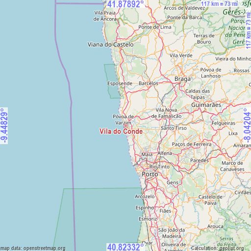
Vila do Conde GPS coordinates[2]
41° 21' 11.736" North, 8° 44' 42.576" West
| Map corner | latitude | longitude |
|---|---|---|
| Upper-left | 41.87892°, | -9.44829° |
| Center: | 41.35326°, | -8.74516° |
| Lower-right: | 40.82332°, | -8.04204° |
| Map W x H: | 117.4×117.4 km | = 72.9×72.9mi |
| max Lat: | 42.11337° ⇑14.7% North |
| Vila do Conde: | 41.35326° |
| min Lat: | ⇓85.3% South 32.6448° |
| min Long | Vila do Conde | max Long |
| -31.17847° | -8.74516° | -6.27308° |
| W 34.5%⇐ | ⇒65.5% E |
Elevation
Elevation of Vila do Conde is 19 m = 62 ft, and this is 158 m = 518 ft below average elevation for this country.
| Max E: |
1008 m = 3307 ft | 88.3% |
| Avg. | 177 m = 581 ft | |
| Vila do Conde | 19 m = 62 ft | |
Min E: |
-128 m = -420 ft | 11.7% |
See also: Portugal elevation on elevation.city.
Geographical zone
Vila do Conde is located in North temperate zone (between Tropic of Cancer and the Arctic Circle). Distance of this Northern Tropic circle is 1992.1 km =1237.8 mi to South.| Distance of | km | miles | from Vila do Conde |
|---|---|---|---|
| North Pole | 5409 | 3361 | to North |
| Arctic Circle | 2803.1 | 1741.8 | to North |
| Tropic Cancer | 1992.1 | 1237.8 | to South |
| Equator | 4598.1 | 2857.1 | to South |


Nearby cities:
15 places around Vila do Conde: (largest is in red/bold)
• Aguçadoura
9.1 km =5.7 mi,  342°
342°
• Amorim
5.8 km =3.6 mi,  355°
355°
• Arcos
8.1 km =5 mi,  53°
53°
• Argivai
3 km =1.9 mi,  25°
25°
• Aver-o-Mar
6.5 km =4 mi,  333°
333°
• Balazar
11.6 km =7.2 mi,  60°
60°
• Beiriz de Baixo
5.2 km =3.2 mi,  19°
19°
• Estela
10.7 km =6.6 mi, 357°
• Lavra
10.7 km =6.6 mi,  167°
167°
• Mindelo
4.7 km =2.9 mi,  154°
154°
• Pedroso
6.4 km =4 mi, 357°
• Póvoa de Varzim
3.7 km =2.3 mi, 335°
• Rio Mau
7.9 km =4.9 mi,  43°
43°
• Vairão
6.9 km =4.3 mi,  109°
109°
• Árvore
2.7 km =1.7 mi,  124°
124°
Sources, notices
• [Note1] Compared only with cities in Portugal existing in our database
• [Src1] Map data: © OpenStreetMap contributors (CC-BY-SA)
• [Src2] Other city data from geonames.org with taken over terms of usage.
• [Src3] Geographical zone / Annual Mean Temperature by Robert A. Rohde @ Wikipedia
