Árvore geodata
Árvore (Porto) is a populated place; located in Portugal in Europe/Lisbon (GMT+1) time zone. With population of 5,196 people, there are 409 cities with bigger population in this country. Compared to other cities in Portugal, 84.4% of cities are located further ↓South; 63.8% of cities are located further →East and 77.4% of cities have higher elevation than Árvore. Note1


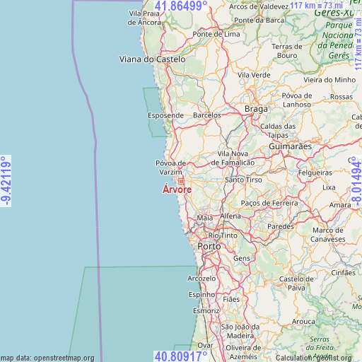
Árvore GPS coordinates[2]
41° 20' 21.192" North, 8° 43' 5.016" West
| Map corner | latitude | longitude |
|---|---|---|
| Upper-left | 41.86499°, | -9.42119° |
| Center: | 41.33922°, | -8.71806° |
| Lower-right: | 40.80917°, | -8.01494° |
| Map W x H: | 117.4×117.4 km | = 72.9×72.9mi |
| max Lat: | 42.11337° ⇑15.6% North |
| Árvore: | 41.33922° |
| min Lat: | ⇓84.4% South 32.6448° |
| min Long | Árvore | max Long |
| -31.17847° | -8.71806° | -6.27308° |
| W 36.2%⇐ | ⇒63.8% E |
Elevation
Elevation of Árvore is 36 m = 118 ft, and this is 141 m = 463 ft below average elevation for this country.
| Max E: |
1008 m = 3307 ft | 77.4% |
| Avg. | 177 m = 581 ft | |
| Árvore | 36 m = 118 ft | |
Min E: |
-128 m = -420 ft | 22.6% |
See also: Portugal elevation on elevation.city.
Geographical zone
Árvore is located in North temperate zone (between Tropic of Cancer and the Arctic Circle). Distance of this Northern Tropic circle is 1990.6 km =1236.9 mi to South.| Distance of | km | miles | from Árvore |
|---|---|---|---|
| North Pole | 5410.6 | 3362 | to North |
| Arctic Circle | 2804.7 | 1742.8 | to North |
| Tropic Cancer | 1990.6 | 1236.9 | to South |
| Equator | 4596.5 | 2856.1 | to South |


Nearby cities:
15 places around Árvore: (largest is in red/bold)
• Amorim
7.8 km =4.8 mi,  339°
339°
• Arcos
7.7 km =4.8 mi,  33°
33°
• Argivai
4.4 km =2.7 mi,  346°
346°
• Aver-o-Mar
9 km =5.6 mi,  325°
325°
• Balazar
10.7 km =6.6 mi,  47°
47°
• Beiriz de Baixo
6.5 km =4 mi,  355°
355°
• Fradelos
10.5 km =6.5 mi,  71°
71°
• Gemunde
10 km =6.2 mi,  142°
142°
• Lavra
8.9 km =5.5 mi,  180°
180°
• Mindelo
2.7 km =1.7 mi,  185°
185°
• Pedroso
8.4 km =5.2 mi, 342°
• Póvoa de Varzim
6.2 km =3.9 mi,  322°
322°
• Rio Mau
7.9 km =4.9 mi,  23°
23°
• Vairão
4.4 km =2.7 mi,  99°
99°
• Vila do Conde
2.7 km =1.7 mi,  304°
304°
Sources, notices
• [Note1] Compared only with cities in Portugal existing in our database
• [Src1] Map data: © OpenStreetMap contributors (CC-BY-SA)
• [Src2] Other city data from geonames.org with taken over terms of usage.
• [Src3] Geographical zone / Annual Mean Temperature by Robert A. Rohde @ Wikipedia
