Argivai geodata
Argivai (Porto) is a populated place; located in Portugal in Europe/Lisbon (GMT+1) time zone. With population of 2,187 people, there are 630 cities with bigger population in this country. Compared to other cities in Portugal, 86.4% of cities are located further ↓South; 64.6% of cities are located further →East and 80.9% of cities have higher elevation than Argivai. Note1


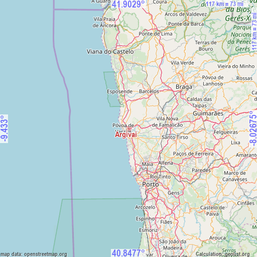
Argivai GPS coordinates[2]
41° 22' 38.784" North, 8° 43' 47.532" West
| Map corner | latitude | longitude |
|---|---|---|
| Upper-left | 41.9029°, | -9.433° |
| Center: | 41.37744°, | -8.72987° |
| Lower-right: | 40.8477°, | -8.02675° |
| Map W x H: | 117.3×117.3 km | = 72.9×72.9mi |
| max Lat: | 42.11337° ⇑13.6% North |
| Argivai: | 41.37744° |
| min Lat: | ⇓86.4% South 32.6448° |
| min Long | Argivai | max Long |
| -31.17847° | -8.72987° | -6.27308° |
| W 35.4%⇐ | ⇒64.6% E |
Elevation
Elevation of Argivai is 32 m = 105 ft, and this is 145 m = 476 ft below average elevation for this country.
| Max E: |
1008 m = 3307 ft | 80.9% |
| Avg. | 177 m = 581 ft | |
| Argivai | 32 m = 105 ft | |
Min E: |
-128 m = -420 ft | 19.1% |
See also: Portugal elevation on elevation.city.
Geographical zone
Argivai is located in North temperate zone (between Tropic of Cancer and the Arctic Circle). Distance of this Northern Tropic circle is 1994.8 km =1239.5 mi to South.| Distance of | km | miles | from Argivai |
|---|---|---|---|
| North Pole | 5406.3 | 3359.3 | to North |
| Arctic Circle | 2800.4 | 1740.1 | to North |
| Tropic Cancer | 1994.8 | 1239.5 | to South |
| Equator | 4600.7 | 2858.7 | to South |


Nearby cities:
15 places around Argivai: (largest is in red/bold)
• Aguçadoura
7.2 km =4.5 mi,  325°
325°
• Amorim
3.5 km =2.2 mi, 330°
• Arcos
5.7 km =3.5 mi,  68°
68°
• Aver-o-Mar
5.2 km =3.2 mi,  307°
307°
• Balazar
9.3 km =5.8 mi, 71°
• Beiriz de Baixo
2.3 km =1.4 mi,  12°
12°
• Estela
8.2 km =5.1 mi,  347°
347°
• Mindelo
7 km =4.3 mi,  174°
174°
• Paradela
10.3 km =6.4 mi,  23°
23°
• Pedroso
4.1 km =2.5 mi,  336°
336°
• Póvoa de Varzim
2.9 km =1.8 mi,  283°
283°
• Rio Mau
5.1 km =3.2 mi,  54°
54°
• Vairão
7.2 km =4.5 mi,  133°
133°
• Vila do Conde
3 km =1.9 mi,  205°
205°
• Árvore
4.4 km =2.7 mi, 166°
Sources, notices
• [Note1] Compared only with cities in Portugal existing in our database
• [Src1] Map data: © OpenStreetMap contributors (CC-BY-SA)
• [Src2] Other city data from geonames.org with taken over terms of usage.
• [Src3] Geographical zone / Annual Mean Temperature by Robert A. Rohde @ Wikipedia
