Ovar geodata
Ovar (Aveiro) is a populated place; located in Portugal in Europe/Lisbon (GMT+1) time zone. With population of 18,452 people, there are 112 cities with bigger population in this country. Compared to other cities in Portugal, 67% of cities are located further ↓South; 55.7% of cities are located further →East and 90.3% of cities have higher elevation than Ovar. Note1


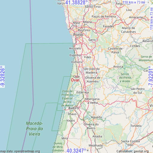
Ovar GPS coordinates[2]
40° 51' 31.032" North, 8° 37' 30.468" West
| Map corner | latitude | longitude |
|---|---|---|
| Upper-left | 41.38828°, | -9.32826° |
| Center: | 40.85862°, | -8.62513° |
| Lower-right: | 40.3247°, | -7.92201° |
| Map W x H: | 118.3×118.3 km | = 73.5×73.5mi |
| max Lat: | 42.11337° ⇑33% North |
| Ovar: | 40.85862° |
| min Lat: | ⇓67% South 32.6448° |
| min Long | Ovar | max Long |
| -31.17847° | -8.62513° | -6.27308° |
| W 44.3%⇐ | ⇒55.7% E |
Elevation
Elevation of Ovar is 16 m = 52 ft, and this is 161 m = 528 ft below average elevation for this country.
| Max E: |
1008 m = 3307 ft | 90.3% |
| Avg. | 177 m = 581 ft | |
| Ovar | 16 m = 52 ft | |
Min E: |
-128 m = -420 ft | 9.7% |
See also: Portugal elevation on elevation.city.
Geographical zone
Ovar is located in North temperate zone (between Tropic of Cancer and the Arctic Circle). Distance of this Northern Tropic circle is 1937.1 km =1203.7 mi to South.| Distance of | km | miles | from Ovar |
|---|---|---|---|
| North Pole | 5464 | 3395.2 | to North |
| Arctic Circle | 2858.1 | 1775.9 | to North |
| Tropic Cancer | 1937.1 | 1203.7 | to South |
| Equator | 4543.1 | 2823 | to South |


Nearby cities:
15 places around Ovar: (largest is in red/bold)
• Avanca
7.2 km =4.5 mi,  141°
141°
• Beduido
11.8 km =7.3 mi,  152°
152°
• Cortegaça
10 km =6.2 mi,  1°
1°
• Cucujães
10.1 km =6.3 mi,  80°
80°
• Esmoriz
11 km =6.8 mi,  358°
358°
• Espargo
8.5 km =5.3 mi,  29°
29°
• Estarreja
12.2 km =7.6 mi,  158°
158°
• Feira
10.1 km =6.3 mi,  43°
43°
• Mosteirô
9 km =5.6 mi,  60°
60°
• Pardilhó
6.6 km =4.1 mi,  180°
180°
• Rio Meão
11.7 km =7.3 mi,  19°
19°
• Sanfins
11.5 km =7.1 mi,  46°
46°
• São João
1.9 km =1.2 mi, 55°
• São João da Madeira
12.3 km =7.6 mi,  67°
67°
• Válega
4.5 km =2.8 mi,  123°
123°
Sources, notices
• [Note1] Compared only with cities in Portugal existing in our database
• [Src1] Map data: © OpenStreetMap contributors (CC-BY-SA)
• [Src2] Other city data from geonames.org with taken over terms of usage.
• [Src3] Geographical zone / Annual Mean Temperature by Robert A. Rohde @ Wikipedia
