Jovim geodata
Jovim (Porto) is a populated place; located in Portugal in Europe/Lisbon (GMT+1) time zone. With population of 7,067 people, there are 319 cities with bigger population in this country. Compared to other cities in Portugal, 74.8% of cities are located further ↓South; 53.6% of cities are located further ←West and 57% of cities have higher elevation than Jovim. Note1


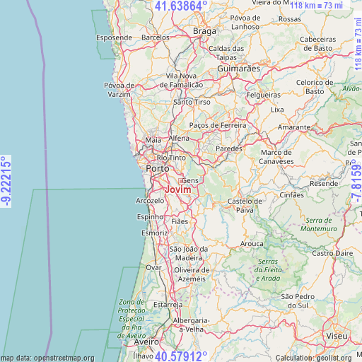
Jovim GPS coordinates[2]
41° 6' 39.672" North, 8° 31' 8.508" West
| Map corner | latitude | longitude |
|---|---|---|
| Upper-left | 41.63864°, | -9.22215° |
| Center: | 41.11102°, | -8.51903° |
| Lower-right: | 40.57912°, | -7.8159° |
| Map W x H: | 117.8×117.8 km | = 73.2×73.2mi |
| max Lat: | 42.11337° ⇑25.2% North |
| Jovim: | 41.11102° |
| min Lat: | ⇓74.8% South 32.6448° |
| min Long | Jovim | max Long |
| -31.17847° | -8.51903° | -6.27308° |
| W 53.6%⇐ | ⇒46.4% E |
Elevation
Elevation of Jovim is 87 m = 285 ft, and this is 90 m = 295 ft below average elevation for this country.
| Max E: |
1008 m = 3307 ft | 57% |
| Avg. | 177 m = 581 ft | |
| Jovim | 87 m = 285 ft | |
Min E: |
-128 m = -420 ft | 43% |
See also: Portugal elevation on elevation.city.
Geographical zone
Jovim is located in North temperate zone (between Tropic of Cancer and the Arctic Circle). Distance of this Northern Tropic circle is 1965.2 km =1221.1 mi to South.| Distance of | km | miles | from Jovim |
|---|---|---|---|
| North Pole | 5435.9 | 3377.7 | to North |
| Arctic Circle | 2830.1 | 1758.5 | to North |
| Tropic Cancer | 1965.2 | 1221.1 | to South |
| Equator | 4571.1 | 2840.3 | to South |


Nearby cities:
15 places around Jovim: (largest is in red/bold)
• Avintes
2.7 km =1.7 mi,  260°
260°
• Canelas
7.5 km =4.7 mi,  245°
245°
• Foz do Sousa
2.1 km =1.3 mi,  137°
137°
• Fânzeres
6.3 km =3.9 mi,  351°
351°
• Gondomar
3.9 km =2.4 mi,  343°
343°
• Olival
7.1 km =4.4 mi,  197°
197°
• Oliveira do Douro
5.7 km =3.5 mi,  285°
285°
• Perozinho
7.5 km =4.7 mi,  227°
227°
• Rio Tinto
8.3 km =5.2 mi, 335°
• Sandim
8.5 km =5.3 mi,  173°
173°
• São Pedro da Cova
3.9 km =2.4 mi,  23°
23°
• Valbom
4.1 km =2.5 mi,  299°
299°
• Valongo
8.8 km =5.5 mi,  11°
11°
• Vila Nova de Gaia
8 km =5 mi,  280°
280°
• Vilar de Andorinho
5.7 km =3.5 mi, 264°
Sources, notices
• [Note1] Compared only with cities in Portugal existing in our database
• [Src1] Map data: © OpenStreetMap contributors (CC-BY-SA)
• [Src2] Other city data from geonames.org with taken over terms of usage.
• [Src3] Geographical zone / Annual Mean Temperature by Robert A. Rohde @ Wikipedia
