Sandim geodata
Sandim (Porto) is a populated place; located in Portugal in Europe/Lisbon (GMT+1) time zone. With population of 6,449 people, there are 342 cities with bigger population in this country. Compared to other cities in Portugal, 71.3% of cities are located further ↓South; 54.1% of cities are located further ←West and 65.2% of cities have lower elevation than Sandim. Note1


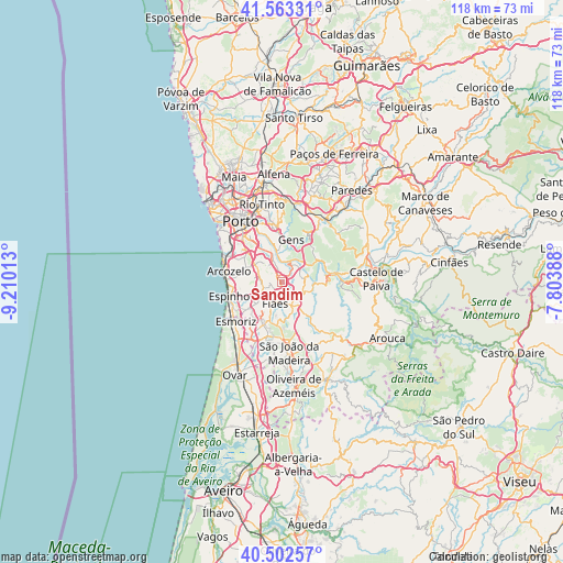
Sandim GPS coordinates[2]
41° 2' 6.288" North, 8° 30' 25.2" West
| Map corner | latitude | longitude |
|---|---|---|
| Upper-left | 41.56331°, | -9.21013° |
| Center: | 41.03508°, | -8.507° |
| Lower-right: | 40.50257°, | -7.80388° |
| Map W x H: | 117.9×117.9 km | = 73.3×73.3mi |
| max Lat: | 42.11337° ⇑28.7% North |
| Sandim: | 41.03508° |
| min Lat: | ⇓71.3% South 32.6448° |
| min Long | Sandim | max Long |
| -31.17847° | -8.507° | -6.27308° |
| W 54.1%⇐ | ⇒45.9% E |
Elevation
Elevation of Sandim is 179 m = 587 ft, and this is 2 m = 7 ft above average elevation for this country.
| Max E: |
1008 m = 3307 ft | 34.8% |
| Sandim | 179 m 587 ft | |
| Avg. | 177 m = 581 ft | |
Min E: |
-128 m = -420 ft | 65.2% |
See also: Portugal elevation on elevation.city.
Geographical zone
Sandim is located in North temperate zone (between Tropic of Cancer and the Arctic Circle). Distance of this Northern Tropic circle is 1956.8 km =1215.9 mi to South.| Distance of | km | miles | from Sandim |
|---|---|---|---|
| North Pole | 5444.4 | 3383 | to North |
| Arctic Circle | 2838.5 | 1763.8 | to North |
| Tropic Cancer | 1956.8 | 1215.9 | to South |
| Equator | 4562.7 | 2835.1 | to South |


Nearby cities:
15 places around Sandim: (largest is in red/bold)
• Argoncilhe
2.9 km =1.8 mi,  248°
248°
• Avintes
8.8 km =5.5 mi,  335°
335°
• Fiães
4.8 km =3 mi,  198°
198°
• Foz do Sousa
6.9 km =4.3 mi,  3°
3°
• Grijó
6.2 km =3.9 mi,  263°
263°
• Jovim
8.5 km =5.3 mi,  353°
353°
• Lamas
7.6 km =4.7 mi,  223°
223°
• Lobão
5.7 km =3.5 mi,  161°
161°
• Lourosa
6.8 km =4.2 mi,  213°
213°
• Nogueira da Regedoura
7.9 km =4.9 mi, 245°
• Olival
3.5 km =2.2 mi,  298°
298°
• Paços de Brandão
9.2 km =5.7 mi, 224°
• Perozinho
7.4 km =4.6 mi, 296°
• Sermonde
6.6 km =4.1 mi,  281°
281°
• Serzedo
9.3 km =5.8 mi, 280°
Sources, notices
• [Note1] Compared only with cities in Portugal existing in our database
• [Src1] Map data: © OpenStreetMap contributors (CC-BY-SA)
• [Src2] Other city data from geonames.org with taken over terms of usage.
• [Src3] Geographical zone / Annual Mean Temperature by Robert A. Rohde @ Wikipedia
