Gemunde geodata
Gemunde (Porto) is a populated place; located in Portugal in Europe/Lisbon (GMT+1) time zone. With population of 5,284 people, there are 404 cities with bigger population in this country. Compared to other cities in Portugal, 82.4% of cities are located further ↓South; 58.3% of cities are located further →East and 55.1% of cities have higher elevation than Gemunde. Note1


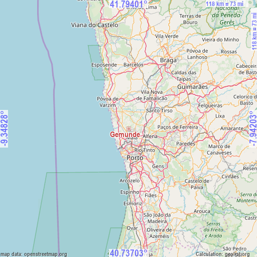
Gemunde GPS coordinates[2]
41° 16' 3.576" North, 8° 38' 42.54" West
| Map corner | latitude | longitude |
|---|---|---|
| Upper-left | 41.79401°, | -9.34828° |
| Center: | 41.26766°, | -8.64515° |
| Lower-right: | 40.73703°, | -7.94203° |
| Map W x H: | 117.5×117.5 km | = 73×73mi |
| max Lat: | 42.11337° ⇑17.6% North |
| Gemunde: | 41.26766° |
| min Lat: | ⇓82.4% South 32.6448° |
| min Long | Gemunde | max Long |
| -31.17847° | -8.64515° | -6.27308° |
| W 41.7%⇐ | ⇒58.3% E |
Elevation
Elevation of Gemunde is 92 m = 302 ft, and this is 85 m = 279 ft below average elevation for this country.
| Max E: |
1008 m = 3307 ft | 55.1% |
| Avg. | 177 m = 581 ft | |
| Gemunde | 92 m = 302 ft | |
Min E: |
-128 m = -420 ft | 44.9% |
See also: Portugal elevation on elevation.city.
Geographical zone
Gemunde is located in North temperate zone (between Tropic of Cancer and the Arctic Circle). Distance of this Northern Tropic circle is 1982.6 km =1231.9 mi to South.| Distance of | km | miles | from Gemunde |
|---|---|---|---|
| North Pole | 5418.5 | 3366.9 | to North |
| Arctic Circle | 2812.6 | 1747.7 | to North |
| Tropic Cancer | 1982.6 | 1231.9 | to South |
| Equator | 4588.5 | 2851.2 | to South |


Nearby cities:
15 places around Gemunde: (largest is in red/bold)
• Anta
1.4 km =0.9 mi,  95°
95°
• Guifões
8.1 km =5 mi,  194°
194°
• Lavra
6.2 km =3.9 mi,  261°
261°
• Leça do Bailio
6.3 km =3.9 mi,  171°
171°
• Maia
4.1 km =2.5 mi,  149°
149°
• Milheirós
7.6 km =4.7 mi,  141°
141°
• Mindelo
8.3 km =5.2 mi,  309°
309°
• Moreira
2.2 km =1.4 mi, 185°
• Nogueira
5.6 km =3.5 mi,  119°
119°
• Santa Cruz do Bispo
6.4 km =4 mi,  202°
202°
• Senhora da Hora
9.1 km =5.7 mi,  183°
183°
• São Mamede de Infesta
8.9 km =5.5 mi,  161°
161°
• São Romão do Coronado
7.1 km =4.4 mi,  73°
73°
• Vairão
7.5 km =4.7 mi,  346°
346°
• Águas Santas
8.6 km =5.3 mi, 137°
Sources, notices
• [Note1] Compared only with cities in Portugal existing in our database
• [Src1] Map data: © OpenStreetMap contributors (CC-BY-SA)
• [Src2] Other city data from geonames.org with taken over terms of usage.
• [Src3] Geographical zone / Annual Mean Temperature by Robert A. Rohde @ Wikipedia
