Póvoa de Lanhoso geodata
Póvoa de Lanhoso (Braga) is a populated place; located in Portugal in Europe/Lisbon (GMT+1) time zone. With population of 5,008 people, there are 422 cities with bigger population in this country. Compared to other cities in Portugal, 95.5% of cities are located further ↓South; 70.1% of cities are located further ←West and 71.4% of cities have lower elevation than Póvoa de Lanhoso. Note1
Administrative division(s):
- Level 1: Braga
- Level 2: Póvoa de Lanhoso
- Level 3: Póvoa de Lanhoso (Nossa Senhora do Amparo)


Póvoa de Lanhoso GPS coordinates[2]
41° 34' 33.564" North, 8° 16' 12.288" West
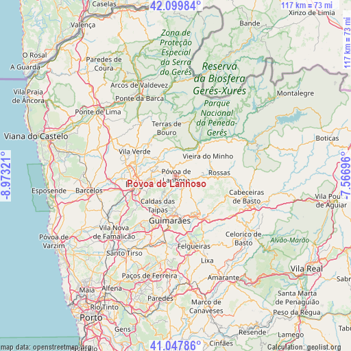
| Map corner | latitude | longitude |
|---|---|---|
| Upper-left | 42.09984°, | -8.97321° |
| Center: | 41.57599°, | -8.27008° |
| Lower-right: | 41.04786°, | -7.56696° |
| Map W x H: | 117×117 km | = 72.7×72.7mi |
| max Lat: | 42.11337° ⇑4.5% North |
| Póvoa de Lanhoso: | 41.57599° |
| min Lat: | ⇓95.5% South 32.6448° |
| min Long | Póvoa de Lanho | max Long |
| -31.17847° | -8.27008° | -6.27308° |
| W 70.1%⇐ | ⇒29.9% E |
Elevation
Elevation of Póvoa de Lanhoso is 209 m = 686 ft, and this is 32 m = 105 ft above average elevation for this country.
| Max E: |
1008 m = 3307 ft | 28.6% |
| Póvoa de Lanhoso | 209 m 686 ft | |
| Avg. | 177 m = 581 ft | |
Min E: |
-128 m = -420 ft | 71.4% |
See also: Portugal elevation on elevation.city.
Geographical zone
Póvoa de Lanhoso is located in North temperate zone (between Tropic of Cancer and the Arctic Circle). Distance of this Northern Tropic circle is 2016.9 km =1253.2 mi to South.| Distance of | km | miles | from Póvoa de Lanhoso |
|---|---|---|---|
| North Pole | 5384.2 | 3345.6 | to North |
| Arctic Circle | 2778.4 | 1726.4 | to North |
| Tropic Cancer | 2016.9 | 1253.2 | to South |
| Equator | 4622.8 | 2872.5 | to South |


Nearby cities:
15 places around Póvoa de Lanhoso: (largest is in red/bold)
• Adaúfe
10.7 km =6.6 mi,  276°
276°
• Amares
9.1 km =5.7 mi,  312°
312°
• Arcos
14 km =8.7 mi,  244°
244°
• Arões
14.2 km =8.8 mi,  160°
160°
• Braga
12.8 km =8 mi,  257°
257°
• Caldas das Taipas
12.1 km =7.5 mi,  212°
212°
• Caldelas
14 km =8.7 mi,  318°
318°
• Esporões
14.3 km =8.9 mi, 239°
• Ferreiros
9.9 km =6.2 mi, 308°
• Goães
9.8 km =6.1 mi,  340°
340°
• Lago
12.9 km =8 mi,  293°
293°
• Ponte
12.7 km =7.9 mi,  203°
203°
• Real
14.5 km =9 mi, 262°
• Rendufe
12.9 km =8 mi,  297°
297°
• Vieira do Minho
12.4 km =7.7 mi,  59°
59°
Sources, notices
• [Note1] Compared only with cities in Portugal existing in our database
• [Src1] Map data: © OpenStreetMap contributors (CC-BY-SA)
• [Src2] Other city data from geonames.org with taken over terms of usage.
• [Src3] Geographical zone / Annual Mean Temperature by Robert A. Rohde @ Wikipedia
