Vizela geodata
Vizela (Porto) is a populated place; located in Portugal in Europe/Lisbon (GMT+1) time zone. With population of 4,066 people, there are 512 cities with bigger population in this country. Compared to other cities in Portugal, 86.7% of cities are located further ↓South; 71.4% of cities are located further ←West and 75.2% of cities have lower elevation than Vizela. Note1


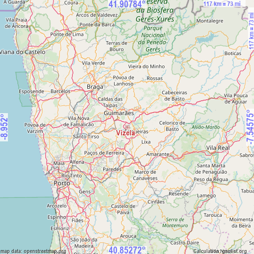
Vizela GPS coordinates[2]
41° 22' 56.712" North, 8° 14' 55.932" West
| Map corner | latitude | longitude |
|---|---|---|
| Upper-left | 41.90784°, | -8.952° |
| Center: | 41.38242°, | -8.24887° |
| Lower-right: | 40.85272°, | -7.54575° |
| Map W x H: | 117.3×117.3 km | = 72.9×72.9mi |
| max Lat: | 42.11337° ⇑13.3% North |
| Vizela: | 41.38242° |
| min Lat: | ⇓86.7% South 32.6448° |
| min Long | Vizela | max Long |
| -31.17847° | -8.24887° | -6.27308° |
| W 71.4%⇐ | ⇒28.6% E |
Elevation
Elevation of Vizela is 238 m = 781 ft, and this is 61 m = 200 ft above average elevation for this country.
| Max E: |
1008 m = 3307 ft | 24.8% |
| Vizela | 238 m 781 ft | |
| Avg. | 177 m = 581 ft | |
Min E: |
-128 m = -420 ft | 75.2% |
See also: Portugal elevation on elevation.city.
Geographical zone
Vizela is located in North temperate zone (between Tropic of Cancer and the Arctic Circle). Distance of this Northern Tropic circle is 1995.4 km =1239.9 mi to South.| Distance of | km | miles | from Vizela |
|---|---|---|---|
| North Pole | 5405.8 | 3359 | to North |
| Arctic Circle | 2799.9 | 1739.8 | to North |
| Tropic Cancer | 1995.4 | 1239.9 | to South |
| Equator | 4601.3 | 2859.1 | to South |


Nearby cities:
15 places around Vizela: (largest is in red/bold)
• Arões
8.6 km =5.3 mi,  19°
19°
• Barrosas
5.2 km =3.2 mi,  234°
234°
• Caldas de Vizela
5 km =3.1 mi,  269°
269°
• Candoso
7.9 km =4.9 mi,  309°
309°
• Fafe
9.9 km =6.2 mi,  39°
39°
• Felgueiras
4.9 km =3 mi,  109°
109°
• Guimarães
7.9 km =4.9 mi,  330°
330°
• Lustosa
7.3 km =4.5 mi, 230°
• Margaride
4.5 km =2.8 mi,  115°
115°
• Moreira de Conegos
7.6 km =4.7 mi, 273°
• Selho
9.1 km =5.7 mi,  296°
296°
• Serzedo
3 km =1.9 mi,  33°
33°
• Urgeses
6.4 km =4 mi,  320°
320°
• Vilarinho
7.3 km =4.5 mi,  249°
249°
• Vizela
1.6 km =1 mi, 307°
Sources, notices
• [Note1] Compared only with cities in Portugal existing in our database
• [Src1] Map data: © OpenStreetMap contributors (CC-BY-SA)
• [Src2] Other city data from geonames.org with taken over terms of usage.
• [Src3] Geographical zone / Annual Mean Temperature by Robert A. Rohde @ Wikipedia
