Ybytymi geodata
Ybytymi (Paraguarí) is a populated place; located in Paraguay in America/Asuncion (GMT-4) time zone. With population of 525 people, there are 160 cities with bigger population in this country. Compared to other cities in Paraguay, 61.7% of cities are located further ↑North; 54.3% of cities are located further →East and 62.3% of cities have lower elevation than Ybytymi. Note1


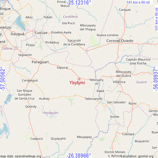
Ybytymi GPS coordinates[2]
25° 45' 29.16" South, 56° 48' 8.964" West
| Map corner | latitude | longitude |
|---|---|---|
| Upper-left | -25.12316°, | -57.50562° |
| Center: | -25.7581°, | -56.80249° |
| Lower-right: | -26.38966°, | -56.09937° |
| Map W x H: | 140.8×140.8 km | = 87.5×87.5mi |
| max Lat: | -19.91667° ⇑61.7% North |
| Ybytymi: | -25.7581° |
| min Lat: | ⇓38.3% South -27.38662° |
| min Long | Ybytymi | max Long |
| -60.78333° | -56.80249° | -54.30694° |
| W 45.7%⇐ | ⇒54.3% E |
Elevation
Elevation of Ybytymi is 167 m = 548 ft, and this is 2.7 m = 9 ft below average elevation for this country.
| Max E: |
658 m = 2159 ft | 37.7% |
| Avg. | 169.7 m = 557 ft | |
| Ybytymi | 167 m = 548 ft | |
Min E: |
46 m = 151 ft | 62.3% |
See also: Paraguay elevation on elevation.city.
Geographical zone
Ybytymi is located in South temperate zone (between Tropic of Capricorn and the Antarctic Circle). Distance of this Southern Tropic circle is 258.1 km =160.4 mi to North.| Distance of | km | miles | from Ybytymi |
|---|---|---|---|
| Equator | 2864 | 1779.6 | to North |
| Tropic Capricorn | 258.1 | 160.4 | to North |
| Antarctic Circle | 4537.1 | 2819.2 | to South |
| South Pole | 7143 | 4438.5 | to South |


Nearby cities:
15 places around Ybytymi: (largest is in red/bold)
• Acahay
39 km =24.2 mi,  243°
243°
• Coronel Martínez
18.6 km =11.6 mi,  90°
90°
• Félix Pérez Cardozo
28.1 km =17.5 mi, 86°
• Itacurubí de la Cordillera
33.4 km =20.8 mi,  351°
351°
• Itapé
21.6 km =13.4 mi,  118°
118°
• La Colmena
14.8 km =9.2 mi,  195°
195°
• Mbocayaty
38.4 km =23.9 mi,  83°
83°
• Paraguarí
37.8 km =23.5 mi,  293°
293°
• Piribebuy
40.5 km =25.2 mi,  323°
323°
• San José
25.9 km =16.1 mi,  15°
15°
• Santa Elena
38.3 km =23.8 mi,  0°
0°
• Sapucaí
18.1 km =11.2 mi,  304°
304°
• Valenzuela
19.3 km =12 mi,  339°
339°
• Villarrica
36.8 km =22.9 mi, 88°
• Ybycuí
37.9 km =23.5 mi,  220°
220°
Sources, notices
• [Note1] Compared only with cities in Paraguay existing in our database
• [Src1] Map data: © OpenStreetMap contributors (CC-BY-SA)
• [Src2] Other city data from geonames.org with taken over terms of usage.
• [Src3] Geographical zone / Annual Mean Temperature by Robert A. Rohde @ Wikipedia
