Sapucaí geodata
Sapucaí (Paraguarí) is a seat of a second-order administrative division; located in Paraguay in America/Asuncion (GMT-4) time zone. With population of 1,932 people, there are 112 cities with bigger population in this country. Compared to other cities in Paraguay, 58.6% of cities are located further ↑North; 62.3% of cities are located further →East and 64.2% of cities have lower elevation than Sapucaí. Note1


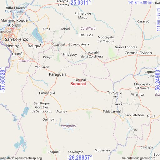
Sapucaí GPS coordinates[2]
25° 39' 59.472" South, 56° 57' 7.74" West
| Map corner | latitude | longitude |
|---|---|---|
| Upper-left | -25.0311°, | -57.65528° |
| Center: | -25.66652°, | -56.95215° |
| Lower-right: | -26.29857°, | -56.24903° |
| Map W x H: | 140.9×140.9 km | = 87.6×87.6mi |
| max Lat: | -19.91667° ⇑58.6% North |
| Sapucaí: | -25.66652° |
| min Lat: | ⇓41.4% South -27.38662° |
| min Long | Sapucaí | max Long |
| -60.78333° | -56.95215° | -54.30694° |
| W 37.7%⇐ | ⇒62.3% E |
Elevation
Elevation of Sapucaí is 171 m = 561 ft, and this is 1.3 m = 4 ft above average elevation for this country.
| Max E: |
658 m = 2159 ft | 35.8% |
| Sapucaí | 171 m 561 ft | |
| Avg. | 169.7 m = 557 ft | |
Min E: |
46 m = 151 ft | 64.2% |
See also: Paraguay elevation on elevation.city.
Geographical zone
Sapucaí is located in South temperate zone (between Tropic of Capricorn and the Antarctic Circle). Distance of this Southern Tropic circle is 247.9 km =154 mi to North.| Distance of | km | miles | from Sapucaí |
|---|---|---|---|
| Equator | 2853.8 | 1773.3 | to North |
| Tropic Capricorn | 247.9 | 154 | to North |
| Antarctic Circle | 4547.3 | 2825.6 | to South |
| South Pole | 7153.2 | 4444.8 | to South |


Nearby cities:
15 places around Sapucaí: (largest is in red/bold)
• Acahay
34.1 km =21.2 mi,  215°
215°
• Caacupé
36.6 km =22.7 mi,  328°
328°
• Carapeguá
31.8 km =19.8 mi,  242°
242°
• Coronel Martínez
35.1 km =21.8 mi,  106°
106°
• Eusebio Ayala
31.6 km =19.6 mi,  358°
358°
• Itacurubí de la Cordillera
24.8 km =15.4 mi,  23°
23°
• La Colmena
26.9 km =16.7 mi,  155°
155°
• Paraguarí
20.2 km =12.6 mi,  284°
284°
• Pirayú
34.9 km =21.7 mi,  305°
305°
• Piribebuy
24.1 km =15 mi,  338°
338°
• San José
26.5 km =16.5 mi,  55°
55°
• Santa Elena
32.2 km =20 mi,  28°
28°
• Valenzuela
11.3 km =7 mi,  46°
46°
• Yaguarón
35.2 km =21.9 mi,  289°
289°
• Ybytymi
18.1 km =11.2 mi,  124°
124°
Sources, notices
• [Note1] Compared only with cities in Paraguay existing in our database
• [Src1] Map data: © OpenStreetMap contributors (CC-BY-SA)
• [Src2] Other city data from geonames.org with taken over terms of usage.
• [Src3] Geographical zone / Annual Mean Temperature by Robert A. Rohde @ Wikipedia
