Ghizela geodata
Ghizela (Timiş) is a seat of a second-order administrative division; located in Romania in Europe/Bucharest (GMT+3) time zone. With population of 1,290 people, there are 3547 cities with bigger population in this country. Compared to other cities in Romania, 50.9% of cities are located further ↓South; 96.2% of cities are located further →East and 73.3% of cities have higher elevation than Ghizela. Note1


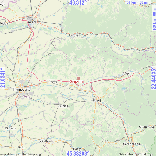
Ghizela GPS coordinates[2]
45° 49' 27.012" North, 21° 44' 13.992" East
| Map corner | latitude | longitude |
|---|---|---|
| Upper-left | 46.312°, | 21.0341° |
| Center: | 45.82417°, | 21.73722° |
| Lower-right: | 45.33203°, | 22.44035° |
| Map W x H: | 109×109 km | = 67.7×67.7mi |
| max Lat: | 48.23793° ⇑49.1% North |
| Ghizela: | 45.82417° |
| min Lat: | ⇓50.9% South 43.65638° |
| min Long | Ghizela | max Long |
| 20.31667° | 21.73722° | 29.65403° |
| W 3.8%⇐ | ⇒96.2% E |
Elevation
Elevation of Ghizela is 116 m = 381 ft, and this is 138.9 m = 456 ft below average elevation for this country.
| Max E: |
1278 m = 4193 ft | 73.3% |
| Avg. | 254.9 m = 836 ft | |
| Ghizela | 116 m = 381 ft | |
Min E: |
-2 m = -7 ft | 26.7% |
See also: Romania elevation on elevation.city.
Geographical zone
Ghizela is located in North temperate zone (between Tropic of Cancer and the Arctic Circle). Distance of this North polar circle is 2306 km =1432.9 mi to North.| Distance of | km | miles | from Ghizela |
|---|---|---|---|
| North Pole | 4911.9 | 3052.1 | to North |
| Arctic Circle | 2306 | 1432.9 | to North |
| Tropic Cancer | 2489.3 | 1546.8 | to South |
| Equator | 5095.2 | 3166 | to South |


Nearby cities:
15 places around Ghizela: (largest is in red/bold)
• Balinţ
9.1 km =5.7 mi,  98°
98°
• Bara
13.1 km =8.1 mi,  53°
53°
• Belinţ
7.9 km =4.9 mi,  166°
166°
• Bodo
11.4 km =7.1 mi,  94°
94°
• Boldur
14.8 km =9.2 mi, 168°
• Brestovăț
6.9 km =4.3 mi,  322°
322°
• Chizătău
7.8 km =4.8 mi,  182°
182°
• Coşteiu
12.7 km =7.9 mi,  136°
136°
• Hitiaș
16.6 km =10.3 mi,  220°
220°
• Iosifalău
6.4 km =4 mi, 222°
• Ohaba-Forgaci
11.7 km =7.3 mi, 178°
• Racoviţa
16.1 km =10 mi,  209°
209°
• Secaş
9.3 km =5.8 mi,  43°
43°
• Topolovăţu Mare
10.7 km =6.6 mi,  238°
238°
• Șanovița
2.9 km =1.8 mi,  190°
190°
Sources, notices
• [Note1] Compared only with cities in Romania existing in our database
• [Src1] Map data: © OpenStreetMap contributors (CC-BY-SA)
• [Src2] Other city data from geonames.org with taken over terms of usage.
• [Src3] Geographical zone / Annual Mean Temperature by Robert A. Rohde @ Wikipedia
