Șanovița geodata
Șanovița (Timiş) is a populated place; located in Romania in Europe/Bucharest (GMT+3) time zone. With population of 524 people, there are 6827 cities with bigger population in this country. Compared to other cities in Romania, 50.3% of cities are located further ↓South; 96.3% of cities are located further →East and 74.8% of cities have higher elevation than Șanovița. Note1


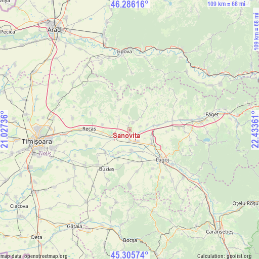
Șanovița GPS coordinates[2]
45° 47' 53.196" North, 21° 43' 49.728" East
| Map corner | latitude | longitude |
|---|---|---|
| Upper-left | 46.28616°, | 21.02736° |
| Center: | 45.79811°, | 21.73048° |
| Lower-right: | 45.30574°, | 22.43361° |
| Map W x H: | 109×109 km | = 67.7×67.7mi |
| max Lat: | 48.23793° ⇑49.7% North |
| Șanovița: | 45.79811° |
| min Lat: | ⇓50.3% South 43.65638° |
| min Long | Șanovița | max Long |
| 20.31667° | 21.73048° | 29.65403° |
| W 3.7%⇐ | ⇒96.3% E |
Elevation
Elevation of Șanovița is 111 m = 364 ft, and this is 143.9 m = 472 ft below average elevation for this country.
| Max E: |
1278 m = 4193 ft | 74.8% |
| Avg. | 254.9 m = 836 ft | |
| Șanovița | 111 m = 364 ft | |
Min E: |
-2 m = -7 ft | 25.2% |
See also: Romania elevation on elevation.city.
Geographical zone
Șanovița is located in North temperate zone (between Tropic of Cancer and the Arctic Circle). Distance of this North polar circle is 2308.9 km =1434.7 mi to North.| Distance of | km | miles | from Șanovița |
|---|---|---|---|
| North Pole | 4914.8 | 3053.9 | to North |
| Arctic Circle | 2308.9 | 1434.7 | to North |
| Tropic Cancer | 2486.4 | 1545 | to South |
| Equator | 5092.3 | 3164.2 | to South |


Nearby cities:
15 places around Șanovița: (largest is in red/bold)
• Balinţ
9.7 km =6 mi,  80°
80°
• Belinţ
5.3 km =3.3 mi,  154°
154°
• Bodo
12.1 km =7.5 mi, 80°
• Boldur
12.1 km =7.5 mi,  162°
162°
• Brestovăț
9.2 km =5.7 mi,  335°
335°
• Chizătău
4.9 km =3 mi,  178°
178°
• Coşteiu
11.2 km =7 mi,  124°
124°
• Ghizela
2.9 km =1.8 mi,  10°
10°
• Hitiaș
14.1 km =8.8 mi,  226°
226°
• Iosifalău
4.2 km =2.6 mi,  244°
244°
• Ohaba-Forgaci
8.9 km =5.5 mi,  174°
174°
• Racoviţa
13.3 km =8.3 mi,  213°
213°
• Secaş
11.9 km =7.4 mi,  35°
35°
• Sinersig
13.9 km =8.6 mi, 182°
• Topolovăţu Mare
9.1 km =5.7 mi,  252°
252°
Sources, notices
• [Note1] Compared only with cities in Romania existing in our database
• [Src1] Map data: © OpenStreetMap contributors (CC-BY-SA)
• [Src2] Other city data from geonames.org with taken over terms of usage.
• [Src3] Geographical zone / Annual Mean Temperature by Robert A. Rohde @ Wikipedia
