Sânmărtin geodata
Sânmărtin (Cluj) is a seat of a second-order administrative division; located in Romania in Europe/Bucharest (GMT+3) time zone. With population of 296 people, there are 7057 cities with bigger population in this country. Compared to other cities in Romania, 79.2% of cities are located further ↓South; 68.1% of cities are located further →East and 69% of cities have lower elevation than Sânmărtin. Note1


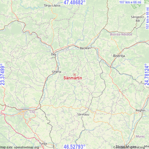
Sânmărtin GPS coordinates[2]
47° 0' 34.308" North, 24° 4' 41.196" East
| Map corner | latitude | longitude |
|---|---|---|
| Upper-left | 47.48682°, | 23.37499° |
| Center: | 47.00953°, | 24.07811° |
| Lower-right: | 46.52793°, | 24.78124° |
| Map W x H: | 106.6×106.6 km | = 66.2×66.2mi |
| max Lat: | 48.23793° ⇑20.8% North |
| Sânmărtin: | 47.00953° |
| min Lat: | ⇓79.2% South 43.65638° |
| min Long | Sânmărtin | max Long |
| 20.31667° | 24.07811° | 29.65403° |
| W 31.9%⇐ | ⇒68.1% E |
Elevation
Elevation of Sânmărtin is 312 m = 1024 ft, and this is 57.1 m = 187 ft above average elevation for this country.
| Max E: |
1278 m = 4193 ft | 31% |
| Sânmărtin | 312 m 1024 ft | |
| Avg. | 254.9 m = 836 ft | |
Min E: |
-2 m = -7 ft | 69% |
See also: Romania elevation on elevation.city.
Geographical zone
Sânmărtin is located in North temperate zone (between Tropic of Cancer and the Arctic Circle). Distance of this North polar circle is 2174.2 km =1351 mi to North.| Distance of | km | miles | from Sânmărtin |
|---|---|---|---|
| North Pole | 4780.1 | 2970.2 | to North |
| Arctic Circle | 2174.2 | 1351 | to North |
| Tropic Cancer | 2621.1 | 1628.7 | to South |
| Equator | 5227 | 3247.9 | to South |


Nearby cities:
15 places around Sânmărtin: (largest is in red/bold)
• Batin
7.1 km =4.4 mi,  349°
349°
• Beudiu
9.3 km =5.8 mi,  49°
49°
• Bozieș
9 km =5.6 mi,  72°
72°
• Buza
13.3 km =8.3 mi,  155°
155°
• Chiochiş
8.5 km =5.3 mi,  110°
110°
• Cutca
2.5 km =1.6 mi,  2°
2°
• Fizeşu Gherlii
7.2 km =4.5 mi,  276°
276°
• Gherla
12.5 km =7.8 mi, 282°
• Malin
13 km =8.1 mi,  20°
20°
• Mintiu Gherlii
10.7 km =6.6 mi,  294°
294°
• Nicula
10.3 km =6.4 mi,  269°
269°
• Năsal
7.7 km =4.8 mi, 160°
• Sântioana
6.7 km =4.2 mi,  228°
228°
• Unguraş
12.1 km =7.5 mi, 349°
• Ţaga
7 km =4.3 mi,  197°
197°
Sources, notices
• [Note1] Compared only with cities in Romania existing in our database
• [Src1] Map data: © OpenStreetMap contributors (CC-BY-SA)
• [Src2] Other city data from geonames.org with taken over terms of usage.
• [Src3] Geographical zone / Annual Mean Temperature by Robert A. Rohde @ Wikipedia
