Mârza geodata
Mârza (Dolj) is a populated place; located in Romania in Europe/Bucharest (GMT+3) time zone. With population of 543 people, there are 6655 cities with bigger population in this country. Compared to other cities in Romania, 93.4% of cities are located further ↑North; 77.4% of cities are located further →East and 65.2% of cities have higher elevation than Mârza. Note1


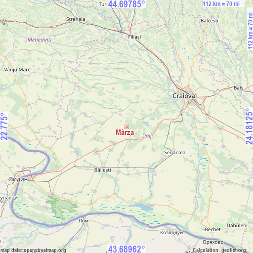
Mârza GPS coordinates[2]
44° 11' 45.204" North, 23° 28' 41.232" East
| Map corner | latitude | longitude |
|---|---|---|
| Upper-left | 44.69785°, | 22.775° |
| Center: | 44.19589°, | 23.47812° |
| Lower-right: | 43.68962°, | 24.18125° |
| Map W x H: | 112.1×112.1 km | = 69.7×69.7mi |
| max Lat: | 48.23793° ⇑93.4% North |
| Mârza: | 44.19589° |
| min Lat: | ⇓6.6% South 43.65638° |
| min Long | Mârza | max Long |
| 20.31667° | 23.47812° | 29.65403° |
| W 22.6%⇐ | ⇒77.4% E |
Elevation
Elevation of Mârza is 146 m = 479 ft, and this is 108.9 m = 357 ft below average elevation for this country.
| Max E: |
1278 m = 4193 ft | 65.2% |
| Avg. | 254.9 m = 836 ft | |
| Mârza | 146 m = 479 ft | |
Min E: |
-2 m = -7 ft | 34.8% |
See also: Romania elevation on elevation.city.
Geographical zone
Mârza is located in North temperate zone (between Tropic of Cancer and the Arctic Circle). Distance of this Northern Tropic circle is 2308.2 km =1434.2 mi to South.| Distance of | km | miles | from Mârza |
|---|---|---|---|
| North Pole | 5092.9 | 3164.6 | to North |
| Arctic Circle | 2487.1 | 1545.4 | to North |
| Tropic Cancer | 2308.2 | 1434.2 | to South |
| Equator | 4914.1 | 3053.5 | to South |


Nearby cities:
15 places around Mârza: (largest is in red/bold)
• Cioroiași
12.7 km =7.9 mi,  190°
190°
• Căciulatu
13.9 km =8.6 mi,  340°
340°
• Galiciuica
12.4 km =7.7 mi,  214°
214°
• Giubega
9.5 km =5.9 mi,  216°
216°
• Perișor
5.9 km =3.7 mi,  182°
182°
• Plopșor
7.9 km =4.9 mi,  319°
319°
• Radovan
11.5 km =7.1 mi,  106°
106°
• Sălcuţa
7 km =4.3 mi,  329°
329°
• Tencănău
3.6 km =2.2 mi,  10°
10°
• Terpeziţa
10.9 km =6.8 mi, 11°
• Vela
10.9 km =6.8 mi, 333°
• Vârtop
10.4 km =6.5 mi,  276°
276°
• Vârvor
12.1 km =7.5 mi,  74°
74°
• Vârvoru de Jos
11.7 km =7.3 mi,  62°
62°
• Întorsura
12.1 km =7.5 mi,  140°
140°
Sources, notices
• [Note1] Compared only with cities in Romania existing in our database
• [Src1] Map data: © OpenStreetMap contributors (CC-BY-SA)
• [Src2] Other city data from geonames.org with taken over terms of usage.
• [Src3] Geographical zone / Annual Mean Temperature by Robert A. Rohde @ Wikipedia
