Tencănău geodata
Tencănău (Dolj) is a populated place; located in Romania in Europe/Bucharest (GMT+3) time zone. With population of 600 people, there are 6202 cities with bigger population in this country. Compared to other cities in Romania, 92.8% of cities are located further ↑North; 77.1% of cities are located further →East and 71.4% of cities have higher elevation than Tencănău. Note1


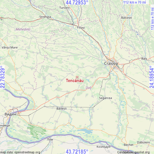
Tencănău GPS coordinates[2]
44° 13' 40.26" North, 23° 29' 11.076" East
| Map corner | latitude | longitude |
|---|---|---|
| Upper-left | 44.72953°, | 22.78329° |
| Center: | 44.22785°, | 23.48641° |
| Lower-right: | 43.72185°, | 24.18954° |
| Map W x H: | 112×112 km | = 69.6×69.6mi |
| max Lat: | 48.23793° ⇑92.8% North |
| Tencănău: | 44.22785° |
| min Lat: | ⇓7.2% South 43.65638° |
| min Long | Tencănău | max Long |
| 20.31667° | 23.48641° | 29.65403° |
| W 22.9%⇐ | ⇒77.1% E |
Elevation
Elevation of Tencănău is 122 m = 400 ft, and this is 132.9 m = 436 ft below average elevation for this country.
| Max E: |
1278 m = 4193 ft | 71.4% |
| Avg. | 254.9 m = 836 ft | |
| Tencănău | 122 m = 400 ft | |
Min E: |
-2 m = -7 ft | 28.6% |
See also: Romania elevation on elevation.city.
Geographical zone
Tencănău is located in North temperate zone (between Tropic of Cancer and the Arctic Circle). Distance of this Northern Tropic circle is 2311.8 km =1436.5 mi to South.| Distance of | km | miles | from Tencănău |
|---|---|---|---|
| North Pole | 5089.4 | 3162.4 | to North |
| Arctic Circle | 2483.5 | 1543.2 | to North |
| Tropic Cancer | 2311.8 | 1436.5 | to South |
| Equator | 4917.7 | 3055.7 | to South |


Nearby cities:
15 places around Tencănău: (largest is in red/bold)
• Bucovicior
13.2 km =8.2 mi,  306°
306°
• Căciulatu
10.9 km =6.8 mi,  331°
331°
• Giubega
12.8 km =8 mi,  209°
209°
• Gubaucea
12.8 km =8 mi,  297°
297°
• Mârza
3.6 km =2.2 mi,  190°
190°
• Perișor
9.4 km =5.8 mi, 185°
• Pleșoi
14.2 km =8.8 mi,  15°
15°
• Plopșor
6.3 km =3.9 mi,  293°
293°
• Radovan
12.4 km =7.7 mi,  123°
123°
• Sălcuţa
4.9 km =3 mi, 300°
• Terpeziţa
7.3 km =4.5 mi,  12°
12°
• Vela
8.3 km =5.2 mi,  318°
318°
• Vârtop
11.2 km =7 mi,  257°
257°
• Vârvor
11 km =6.8 mi,  91°
91°
• Vârvoru de Jos
9.8 km =6.1 mi,  79°
79°
Sources, notices
• [Note1] Compared only with cities in Romania existing in our database
• [Src1] Map data: © OpenStreetMap contributors (CC-BY-SA)
• [Src2] Other city data from geonames.org with taken over terms of usage.
• [Src3] Geographical zone / Annual Mean Temperature by Robert A. Rohde @ Wikipedia
