Coşoveni geodata
Coşoveni (Dolj) is a seat of a second-order administrative division; located in Romania in Europe/Bucharest (GMT+3) time zone. With population of 5,024 people, there are 775 cities with bigger population in this country. Compared to other cities in Romania, 92.1% of cities are located further ↑North; 70.7% of cities are located further →East and 58.7% of cities have higher elevation than Coşoveni. Note1


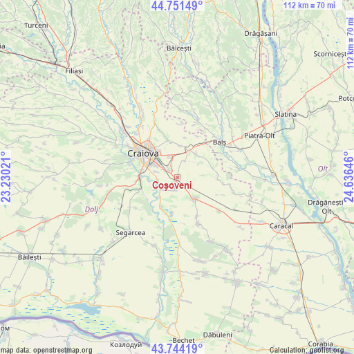
Coşoveni GPS coordinates[2]
44° 15' 0" North, 23° 55' 59.988" East
| Map corner | latitude | longitude |
|---|---|---|
| Upper-left | 44.75149°, | 23.23021° |
| Center: | 44.25°, | 23.93333° |
| Lower-right: | 43.74419°, | 24.63646° |
| Map W x H: | 112×112 km | = 69.6×69.6mi |
| max Lat: | 48.23793° ⇑92.1% North |
| Coşoveni: | 44.25° |
| min Lat: | ⇓7.9% South 43.65638° |
| min Long | Coşoveni | max Long |
| 20.31667° | 23.93333° | 29.65403° |
| W 29.3%⇐ | ⇒70.7% E |
Elevation
Elevation of Coşoveni is 171 m = 561 ft, and this is 83.9 m = 275 ft below average elevation for this country.
| Max E: |
1278 m = 4193 ft | 58.7% |
| Avg. | 254.9 m = 836 ft | |
| Coşoveni | 171 m = 561 ft | |
Min E: |
-2 m = -7 ft | 41.3% |
See also: Romania elevation on elevation.city.
Geographical zone
Coşoveni is located in North temperate zone (between Tropic of Cancer and the Arctic Circle). Distance of this Northern Tropic circle is 2314.2 km =1438 mi to South.| Distance of | km | miles | from Coşoveni |
|---|---|---|---|
| North Pole | 5086.9 | 3160.9 | to North |
| Arctic Circle | 2481 | 1541.6 | to North |
| Tropic Cancer | 2314.2 | 1438 | to South |
| Equator | 4920.1 | 3057.2 | to South |


Nearby cities:
15 places around Coşoveni: (largest is in red/bold)
• Braniște
11.6 km =7.2 mi,  281°
281°
• Bădoși
11.9 km =7.4 mi,  196°
196°
• Cârcea
3.4 km =2.1 mi,  308°
308°
• Făcăi
9.4 km =5.8 mi,  286°
286°
• Ghindeni
4.3 km =2.7 mi,  190°
190°
• Golfin
8.3 km =5.2 mi,  56°
56°
• Leu
9.1 km =5.7 mi,  144°
144°
• Livezi
11.7 km =7.3 mi,  259°
259°
• Malu Mare
6.4 km =4 mi, 261°
• Pieleştí
9.4 km =5.8 mi,  8°
8°
• Preajba
6.8 km =4.2 mi, 284°
• Robăneștii de Sus
9.9 km =6.2 mi,  36°
36°
• Secui
8.5 km =5.3 mi,  220°
220°
• Teasc
11 km =6.8 mi,  209°
209°
• Ţuglui
11.9 km =7.4 mi,  231°
231°
Sources, notices
• [Note1] Compared only with cities in Romania existing in our database
• [Src1] Map data: © OpenStreetMap contributors (CC-BY-SA)
• [Src2] Other city data from geonames.org with taken over terms of usage.
• [Src3] Geographical zone / Annual Mean Temperature by Robert A. Rohde @ Wikipedia
