Golfin geodata
Golfin (Dolj) is a populated place; located in Romania in Europe/Bucharest (GMT+3) time zone. With population of 928 people, there are 4521 cities with bigger population in this country. Compared to other cities in Romania, 91% of cities are located further ↑North; 68.9% of cities are located further →East and 65.2% of cities have higher elevation than Golfin. Note1


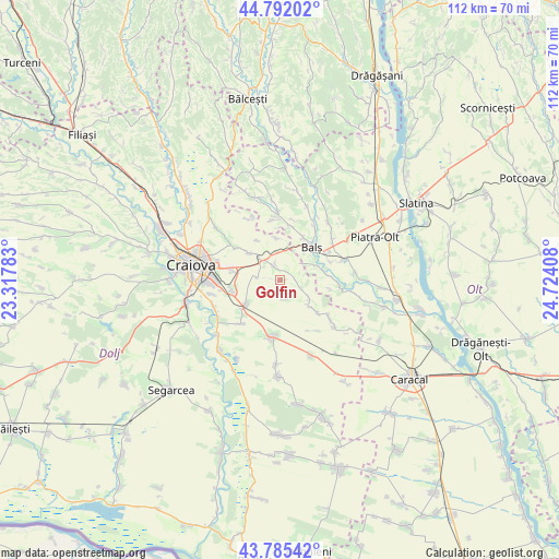
Golfin GPS coordinates[2]
44° 17' 27.168" North, 24° 1' 15.42" East
| Map corner | latitude | longitude |
|---|---|---|
| Upper-left | 44.79202°, | 23.31783° |
| Center: | 44.29088°, | 24.02095° |
| Lower-right: | 43.78542°, | 24.72408° |
| Map W x H: | 111.9×111.9 km | = 69.5×69.5mi |
| max Lat: | 48.23793° ⇑91% North |
| Golfin: | 44.29088° |
| min Lat: | ⇓9% South 43.65638° |
| min Long | Golfin | max Long |
| 20.31667° | 24.02095° | 29.65403° |
| W 31.1%⇐ | ⇒68.9% E |
Elevation
Elevation of Golfin is 146 m = 479 ft, and this is 108.9 m = 357 ft below average elevation for this country.
| Max E: |
1278 m = 4193 ft | 65.2% |
| Avg. | 254.9 m = 836 ft | |
| Golfin | 146 m = 479 ft | |
Min E: |
-2 m = -7 ft | 34.8% |
See also: Romania elevation on elevation.city.
Geographical zone
Golfin is located in North temperate zone (between Tropic of Cancer and the Arctic Circle). Distance of this Northern Tropic circle is 2318.8 km =1440.8 mi to South.| Distance of | km | miles | from Golfin |
|---|---|---|---|
| North Pole | 5082.4 | 3158.1 | to North |
| Arctic Circle | 2476.5 | 1538.8 | to North |
| Tropic Cancer | 2318.8 | 1440.8 | to South |
| Equator | 4924.7 | 3060.1 | to South |


Nearby cities:
15 places around Golfin: (largest is in red/bold)
• Baldovineşti
10.5 km =6.5 mi,  12°
12°
• Balş
9.1 km =5.7 mi,  43°
43°
• Bârza
10.5 km =6.5 mi,  66°
66°
• Coşoveni
8.3 km =5.2 mi,  236°
236°
• Câmpeni
8.5 km =5.3 mi,  356°
356°
• Cârcea
9.9 km =6.2 mi,  255°
255°
• Drăgoteşti
7.8 km =4.8 mi,  125°
125°
• Ghindeni
11.7 km =7.3 mi,  221°
221°
• Mărgăritești
10.1 km =6.3 mi,  85°
85°
• Pieleştí
7.4 km =4.6 mi,  309°
309°
• Racovița
8.3 km =5.2 mi, 71°
• Robăneștii de Sus
3.6 km =2.2 mi,  342°
342°
• Teiș
11.1 km =6.9 mi,  53°
53°
• Viișoara
9.8 km =6.1 mi, 132°
• Voineasa
9 km =5.6 mi,  95°
95°
Sources, notices
• [Note1] Compared only with cities in Romania existing in our database
• [Src1] Map data: © OpenStreetMap contributors (CC-BY-SA)
• [Src2] Other city data from geonames.org with taken over terms of usage.
• [Src3] Geographical zone / Annual Mean Temperature by Robert A. Rohde @ Wikipedia
