Pieleştí geodata
Pieleştí (Dolj) is a seat of a second-order administrative division; located in Romania in Europe/Bucharest (GMT+3) time zone. With population of 3,647 people, there are 1350 cities with bigger population in this country. Compared to other cities in Romania, 90.1% of cities are located further ↑North; 70.3% of cities are located further →East and 61.1% of cities have higher elevation than Pieleştí. Note1


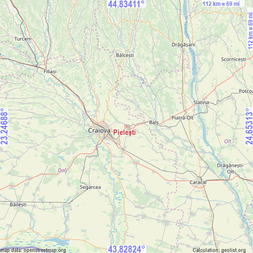
Pieleştí GPS coordinates[2]
44° 19' 59.988" North, 23° 57' 0" East
| Map corner | latitude | longitude |
|---|---|---|
| Upper-left | 44.83411°, | 23.24688° |
| Center: | 44.33333°, | 23.95° |
| Lower-right: | 43.82824°, | 24.65313° |
| Map W x H: | 111.8×111.8 km | = 69.5×69.5mi |
| max Lat: | 48.23793° ⇑90.1% North |
| Pieleştí: | 44.33333° |
| min Lat: | ⇓9.9% South 43.65638° |
| min Long | Pieleştí | max Long |
| 20.31667° | 23.95° | 29.65403° |
| W 29.7%⇐ | ⇒70.3% E |
Elevation
Elevation of Pieleştí is 162 m = 531 ft, and this is 92.9 m = 305 ft below average elevation for this country.
| Max E: |
1278 m = 4193 ft | 61.1% |
| Avg. | 254.9 m = 836 ft | |
| Pieleştí | 162 m = 531 ft | |
Min E: |
-2 m = -7 ft | 38.9% |
See also: Romania elevation on elevation.city.
Geographical zone
Pieleştí is located in North temperate zone (between Tropic of Cancer and the Arctic Circle). Distance of this Northern Tropic circle is 2323.5 km =1443.8 mi to South.| Distance of | km | miles | from Pieleştí |
|---|---|---|---|
| North Pole | 5077.7 | 3155.1 | to North |
| Arctic Circle | 2471.8 | 1535.9 | to North |
| Tropic Cancer | 2323.5 | 1443.8 | to South |
| Equator | 4929.4 | 3063 | to South |


Nearby cities:
15 places around Pieleştí: (largest is in red/bold)
• Baldovineşti
9.7 km =6 mi,  55°
55°
• Balş
12.1 km =7.5 mi,  81°
81°
• Băleasa
8.7 km =5.4 mi,  32°
32°
• Coşoveni
9.4 km =5.8 mi,  188°
188°
• Câmpeni
6.4 km =4 mi,  53°
53°
• Cârcea
8.2 km =5.1 mi,  209°
209°
• Ghercești
4.9 km =3 mi,  300°
300°
• Golfin
7.4 km =4.6 mi,  129°
129°
• Gropșani
12.1 km =7.5 mi,  7°
7°
• Găvănești
10.7 km =6.6 mi, 29°
• Mischii
9.7 km =6 mi, 304°
• Mlecănești
7.8 km =4.8 mi,  308°
308°
• Preajba
11 km =6.8 mi,  226°
226°
• Robăneștii de Sus
4.7 km =2.9 mi,  105°
105°
• Șimnicu de Jos
10.6 km =6.6 mi,  285°
285°
Sources, notices
• [Note1] Compared only with cities in Romania existing in our database
• [Src1] Map data: © OpenStreetMap contributors (CC-BY-SA)
• [Src2] Other city data from geonames.org with taken over terms of usage.
• [Src3] Geographical zone / Annual Mean Temperature by Robert A. Rohde @ Wikipedia
