Bârza geodata
Bârza (Caraş-Severin) is a populated place; located in Romania in Europe/Bucharest (GMT+3) time zone. With population of 602 people, there are 6197 cities with bigger population in this country. Compared to other cities in Romania, 76.3% of cities are located further ↑North; 90.8% of cities are located further →East and 80.8% of cities have higher elevation than Bârza. Note1


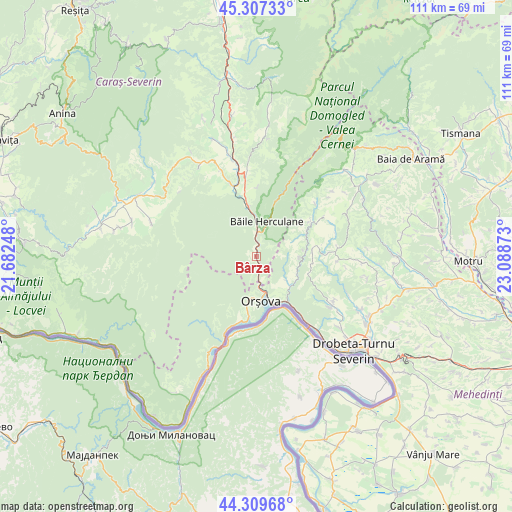
Bârza GPS coordinates[2]
44° 48' 38.376" North, 22° 23' 8.16" East
| Map corner | latitude | longitude |
|---|---|---|
| Upper-left | 45.30733°, | 21.68248° |
| Center: | 44.81066°, | 22.3856° |
| Lower-right: | 44.30968°, | 23.08873° |
| Map W x H: | 110.9×110.9 km | = 68.9×68.9mi |
| max Lat: | 48.23793° ⇑76.3% North |
| Bârza: | 44.81066° |
| min Lat: | ⇓23.7% South 43.65638° |
| min Long | Bârza | max Long |
| 20.31667° | 22.3856° | 29.65403° |
| W 9.2%⇐ | ⇒90.8% E |
Elevation
Elevation of Bârza is 92 m = 302 ft, and this is 162.9 m = 534 ft below average elevation for this country.
| Max E: |
1278 m = 4193 ft | 80.8% |
| Avg. | 254.9 m = 836 ft | |
| Bârza | 92 m = 302 ft | |
Min E: |
-2 m = -7 ft | 19.2% |
See also: Romania elevation on elevation.city.
Geographical zone
Bârza is located in North temperate zone (between Tropic of Cancer and the Arctic Circle). Distance of this Northern Tropic circle is 2376.6 km =1476.8 mi to South.| Distance of | km | miles | from Bârza |
|---|---|---|---|
| North Pole | 5024.6 | 3122.1 | to North |
| Arctic Circle | 2418.7 | 1502.9 | to North |
| Tropic Cancer | 2376.6 | 1476.8 | to South |
| Equator | 4982.5 | 3096 | to South |


Nearby cities:
15 places around Bârza: (largest is in red/bold)
• Băile Herculane
8 km =5 mi,  15°
15°
• Cireşu
12.1 km =7.5 mi,  83°
83°
• Eşelniţa
12.5 km =7.8 mi,  188°
188°
• Godeanu
17.6 km =10.9 mi,  93°
93°
• Iablaniţa
16.5 km =10.3 mi,  340°
340°
• Iloviţa
9.2 km =5.7 mi,  131°
131°
• Jidoștița
19.5 km =12.1 mi,  122°
122°
• Mehadia
10.1 km =6.3 mi,  351°
351°
• Orşova
9.8 km =6.1 mi,  175°
175°
• Pecinișca
5.7 km =3.5 mi, 15°
• Petnic
20.1 km =12.5 mi, 338°
• Plugova
17 km =10.6 mi, 352°
• Podeni
14.7 km =9.1 mi,  57°
57°
• Topleţ
1.6 km =1 mi,  154°
154°
• Valea Bolvașnița
15.1 km =9.4 mi,  1°
1°
Sources, notices
• [Note1] Compared only with cities in Romania existing in our database
• [Src1] Map data: © OpenStreetMap contributors (CC-BY-SA)
• [Src2] Other city data from geonames.org with taken over terms of usage.
• [Src3] Geographical zone / Annual Mean Temperature by Robert A. Rohde @ Wikipedia
