Podeni geodata
Podeni (Mehedinţi) is a seat of a second-order administrative division; located in Romania in Europe/Bucharest (GMT+3) time zone. With population of 1,148 people, there are 3860 cities with bigger population in this country. Compared to other cities in Romania, 73.8% of cities are located further ↑North; 89.4% of cities are located further →East and 83.6% of cities have lower elevation than Podeni. Note1


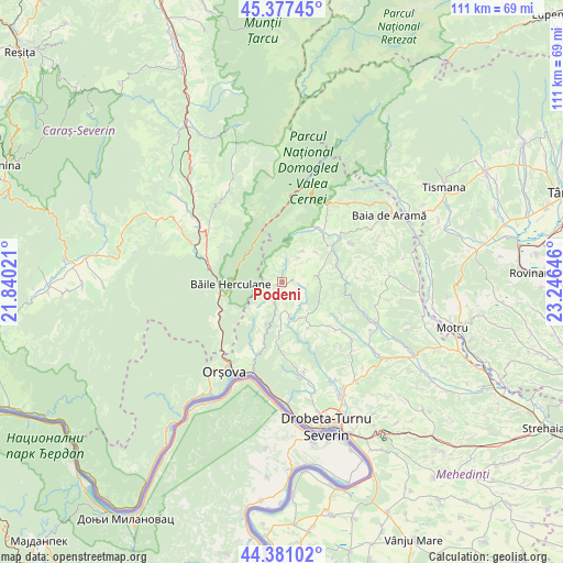
Podeni GPS coordinates[2]
44° 52' 53.004" North, 22° 32' 35.988" East
| Map corner | latitude | longitude |
|---|---|---|
| Upper-left | 45.37745°, | 21.84021° |
| Center: | 44.88139°, | 22.54333° |
| Lower-right: | 44.38102°, | 23.24646° |
| Map W x H: | 110.8×110.8 km | = 68.8×68.8mi |
| max Lat: | 48.23793° ⇑73.8% North |
| Podeni: | 44.88139° |
| min Lat: | ⇓26.2% South 43.65638° |
| min Long | Podeni | max Long |
| 20.31667° | 22.54333° | 29.65403° |
| W 10.6%⇐ | ⇒89.4% E |
Elevation
Elevation of Podeni is 429 m = 1407 ft, and this is 174.1 m = 571 ft above average elevation for this country.
| Max E: |
1278 m = 4193 ft | 16.4% |
| Podeni | 429 m 1407 ft | |
| Avg. | 254.9 m = 836 ft | |
Min E: |
-2 m = -7 ft | 83.6% |
See also: Romania elevation on elevation.city.
Geographical zone
Podeni is located in North temperate zone (between Tropic of Cancer and the Arctic Circle). Distance of this Northern Tropic circle is 2384.4 km =1481.6 mi to South.| Distance of | km | miles | from Podeni |
|---|---|---|---|
| North Pole | 5016.7 | 3117.2 | to North |
| Arctic Circle | 2410.8 | 1498 | to North |
| Tropic Cancer | 2384.4 | 1481.6 | to South |
| Equator | 4990.3 | 3100.8 | to South |


Nearby cities:
15 places around Podeni: (largest is in red/bold)
• Balta
7.4 km =4.6 mi,  85°
85°
• Bâlvăneşti
14.3 km =8.9 mi,  130°
130°
• Bârza
14.7 km =9.1 mi,  237°
237°
• Băile Herculane
10.3 km =6.4 mi,  268°
268°
• Cireşu
6.5 km =4 mi,  183°
183°
• Godeanu
10.3 km =6.4 mi,  150°
150°
• Iloviţa
15 km =9.3 mi,  201°
201°
• Isverna
12.9 km =8 mi,  31°
31°
• Mehadia
14.1 km =8.8 mi,  278°
278°
• Pecinișca
11.1 km =6.9 mi,  257°
257°
• Plugova
17.1 km =10.6 mi,  301°
301°
• Pârlagele
17.4 km =10.8 mi,  137°
137°
• Seliștea
13.5 km =8.4 mi,  38°
38°
• Topleţ
15 km =9.3 mi,  231°
231°
• Valea Bolvașnița
14 km =8.7 mi, 300°
Sources, notices
• [Note1] Compared only with cities in Romania existing in our database
• [Src1] Map data: © OpenStreetMap contributors (CC-BY-SA)
• [Src2] Other city data from geonames.org with taken over terms of usage.
• [Src3] Geographical zone / Annual Mean Temperature by Robert A. Rohde @ Wikipedia
