Cireşu geodata
Cireşu (Mehedinţi) is a seat of a second-order administrative division; located in Romania in Europe/Bucharest (GMT+3) time zone. With population of 813 people, there are 4979 cities with bigger population in this country. Compared to other cities in Romania, 75.8% of cities are located further ↑North; 89.4% of cities are located further →East and 83.9% of cities have lower elevation than Cireşu. Note1


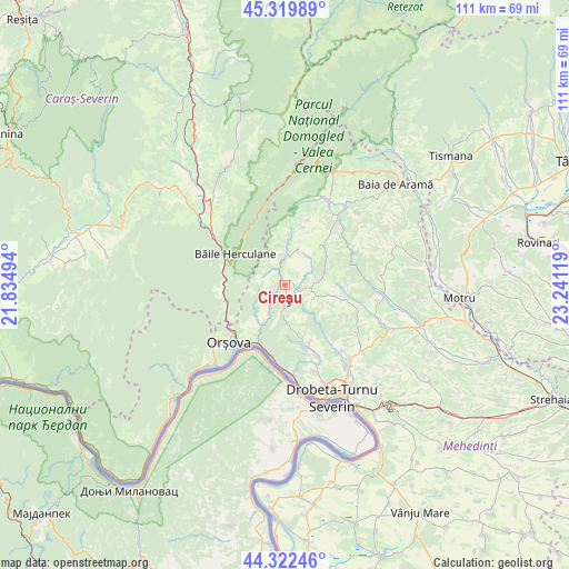
Cireşu GPS coordinates[2]
44° 49' 23.988" North, 22° 32' 17.016" East
| Map corner | latitude | longitude |
|---|---|---|
| Upper-left | 45.31989°, | 21.83494° |
| Center: | 44.82333°, | 22.53806° |
| Lower-right: | 44.32246°, | 23.24119° |
| Map W x H: | 110.9×110.9 km | = 68.9×68.9mi |
| max Lat: | 48.23793° ⇑75.8% North |
| Cireşu: | 44.82333° |
| min Lat: | ⇓24.2% South 43.65638° |
| min Long | Cireşu | max Long |
| 20.31667° | 22.53806° | 29.65403° |
| W 10.6%⇐ | ⇒89.4% E |
Elevation
Elevation of Cireşu is 433 m = 1421 ft, and this is 178.1 m = 584 ft above average elevation for this country.
| Max E: |
1278 m = 4193 ft | 16.1% |
| Cireşu | 433 m 1421 ft | |
| Avg. | 254.9 m = 836 ft | |
Min E: |
-2 m = -7 ft | 83.9% |
See also: Romania elevation on elevation.city.
Geographical zone
Cireşu is located in North temperate zone (between Tropic of Cancer and the Arctic Circle). Distance of this Northern Tropic circle is 2378 km =1477.6 mi to South.| Distance of | km | miles | from Cireşu |
|---|---|---|---|
| North Pole | 5023.2 | 3121.3 | to North |
| Arctic Circle | 2417.3 | 1502 | to North |
| Tropic Cancer | 2378 | 1477.6 | to South |
| Equator | 4983.9 | 3096.9 | to South |


Nearby cities:
15 places around Cireşu: (largest is in red/bold)
• Balta
10.5 km =6.5 mi,  47°
47°
• Bobaița
16.1 km =10 mi,  115°
115°
• Bâlvăneşti
11.6 km =7.2 mi,  104°
104°
• Bârza
12.1 km =7.5 mi,  263°
263°
• Băile Herculane
11.7 km =7.3 mi,  302°
302°
• Godeanu
6.1 km =3.8 mi,  113°
113°
• Iloviţa
9.1 km =5.7 mi,  214°
214°
• Izvoru Bârzii
16.8 km =10.4 mi,  140°
140°
• Jidoștița
12.7 km =7.9 mi,  160°
160°
• Mehadia
16 km =9.9 mi, 302°
• Orşova
15.8 km =9.8 mi,  225°
225°
• Pecinișca
11.2 km =7 mi,  291°
291°
• Podeni
6.5 km =4 mi,  3°
3°
• Pârlagele
13.7 km =8.5 mi, 117°
• Topleţ
11.7 km =7.3 mi, 255°
Sources, notices
• [Note1] Compared only with cities in Romania existing in our database
• [Src1] Map data: © OpenStreetMap contributors (CC-BY-SA)
• [Src2] Other city data from geonames.org with taken over terms of usage.
• [Src3] Geographical zone / Annual Mean Temperature by Robert A. Rohde @ Wikipedia
