Doroslovo geodata
Doroslovo (Vojvodina) is a populated place; located in Serbia in Europe/Belgrade (GMT+2) time zone. With population of 2,131 people, there are 205 cities with bigger population in this country. Compared to other cities in Serbia, 89.1% of cities are located further ↓South; 97.3% of cities are located further →East and 54.9% of cities have higher elevation than Doroslovo. Note1


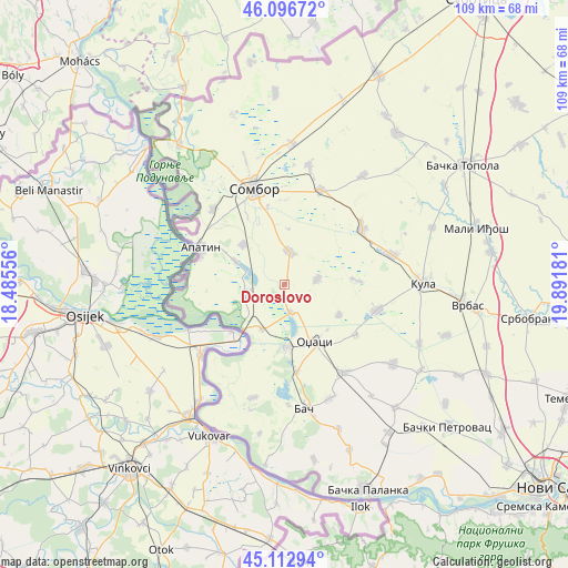
Doroslovo GPS coordinates[2]
45° 36' 25.164" North, 19° 11' 19.248" East
| Map corner | latitude | longitude |
|---|---|---|
| Upper-left | 46.09672°, | 18.48556° |
| Center: | 45.60699°, | 19.18868° |
| Lower-right: | 45.11294°, | 19.89181° |
| Map W x H: | 109.4×109.4 km | = 68×68mi |
| max Lat: | 46.1° ⇑10.9% North |
| Doroslovo: | 45.60699° |
| min Lat: | ⇓89.1% South 42.25846° |
| min Long | Doroslovo | max Long |
| 18.9276° | 19.18868° | 22.77556° |
| W 2.7%⇐ | ⇒97.3% E |
Elevation
Elevation of Doroslovo is 85 m = 279 ft, and this is 91.4 m = 300 ft below average elevation for this country.
| Max E: |
1421 m = 4662 ft | 54.9% |
| Avg. | 176.4 m = 579 ft | |
| Doroslovo | 85 m = 279 ft | |
Min E: |
49 m = 161 ft | 45.1% |
See also: Serbia elevation on elevation.city.
Geographical zone
Doroslovo is located in North temperate zone (between Tropic of Cancer and the Arctic Circle). Distance of this North polar circle is 2330.2 km =1447.9 mi to North.| Distance of | km | miles | from Doroslovo |
|---|---|---|---|
| North Pole | 4936 | 3067.1 | to North |
| Arctic Circle | 2330.2 | 1447.9 | to North |
| Tropic Cancer | 2465.1 | 1531.7 | to South |
| Equator | 5071 | 3151 | to South |


Nearby cities:
15 places around Doroslovo: (largest is in red/bold)
• Apatin
17.9 km =11.1 mi,  294°
294°
• Bač
24.2 km =15 mi,  171°
171°
• Bogojevo
9.7 km =6 mi,  208°
208°
• Despotovo
31 km =19.3 mi,  121°
121°
• Gakovo
34.1 km =21.2 mi,  343°
343°
• Kolut
37.7 km =23.4 mi,  327°
327°
• Kula
26.3 km =16.3 mi,  89°
89°
• Kupusina
20 km =12.4 mi,  316°
316°
• Obrovac
34.2 km =21.3 mi,  158°
158°
• Odžaci
12.5 km =7.8 mi,  153°
153°
• Prigrevica
11 km =6.8 mi,  314°
314°
• Sombor
19.5 km =12.1 mi, 342°
• Sonta
7.3 km =4.5 mi,  258°
258°
• Stanišić
36.9 km =22.9 mi,  357°
357°
• Vrbas
35.4 km =22 mi,  96°
96°
Sources, notices
• [Note1] Compared only with cities in Serbia existing in our database
• [Src1] Map data: © OpenStreetMap contributors (CC-BY-SA)
• [Src2] Other city data from geonames.org with taken over terms of usage.
• [Src3] Geographical zone / Annual Mean Temperature by Robert A. Rohde @ Wikipedia
