Bogojevo geodata
Bogojevo (Vojvodina) is a populated place; located in Serbia in Europe/Belgrade (GMT+2) time zone. With population of 2,312 people, there are 191 cities with bigger population in this country. Compared to other cities in Serbia, 86.2% of cities are located further ↓South; 97.7% of cities are located further →East and 51.2% of cities have higher elevation than Bogojevo. Note1


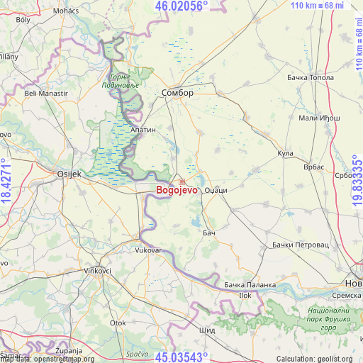
Bogojevo GPS coordinates[2]
45° 31' 48.54" North, 19° 7' 48.792" East
| Map corner | latitude | longitude |
|---|---|---|
| Upper-left | 46.02056°, | 18.4271° |
| Center: | 45.53015°, | 19.13022° |
| Lower-right: | 45.03543°, | 19.83335° |
| Map W x H: | 109.5×109.5 km | = 68×68mi |
| max Lat: | 46.1° ⇑13.8% North |
| Bogojevo: | 45.53015° |
| min Lat: | ⇓86.2% South 42.25846° |
| min Long | Bogojevo | max Long |
| 18.9276° | 19.13022° | 22.77556° |
| W 2.3%⇐ | ⇒97.7% E |
Elevation
Elevation of Bogojevo is 88 m = 289 ft, and this is 88.4 m = 290 ft below average elevation for this country.
| Max E: |
1421 m = 4662 ft | 51.2% |
| Avg. | 176.4 m = 579 ft | |
| Bogojevo | 88 m = 289 ft | |
Min E: |
49 m = 161 ft | 48.8% |
See also: Serbia elevation on elevation.city.
Geographical zone
Bogojevo is located in North temperate zone (between Tropic of Cancer and the Arctic Circle). Distance of this North polar circle is 2338.7 km =1453.2 mi to North.| Distance of | km | miles | from Bogojevo |
|---|---|---|---|
| North Pole | 4944.6 | 3072.4 | to North |
| Arctic Circle | 2338.7 | 1453.2 | to North |
| Tropic Cancer | 2456.6 | 1526.5 | to South |
| Equator | 5062.5 | 3145.7 | to South |


Nearby cities:
15 places around Bogojevo: (largest is in red/bold)
• Apatin
19.8 km =12.3 mi,  323°
323°
• Bač
17.5 km =10.9 mi,  151°
151°
• Bačka Palanka
37.5 km =23.3 mi, 146°
• Despotovo
31.9 km =19.8 mi,  104°
104°
• Doroslovo
9.7 km =6 mi,  28°
28°
• Kula
32.1 km =19.9 mi,  74°
74°
• Kulpin
38.4 km =23.9 mi,  111°
111°
• Kupusina
24.9 km =15.5 mi,  338°
338°
• Maglić
36.5 km =22.7 mi,  120°
120°
• Obrovac
28.9 km =18 mi,  143°
143°
• Odžaci
10.5 km =6.5 mi, 104°
• Prigrevica
16.6 km =10.3 mi,  348°
348°
• Ravno Selo
39.3 km =24.4 mi, 103°
• Sombor
27.2 km =16.9 mi,  357°
357°
• Sonta
7.6 km =4.7 mi, 340°
Sources, notices
• [Note1] Compared only with cities in Serbia existing in our database
• [Src1] Map data: © OpenStreetMap contributors (CC-BY-SA)
• [Src2] Other city data from geonames.org with taken over terms of usage.
• [Src3] Geographical zone / Annual Mean Temperature by Robert A. Rohde @ Wikipedia
