Odžaci geodata
Odžaci (Vojvodina) is a seat of a third-order administrative division; located in Serbia in Europe/Belgrade (GMT+2) time zone. In our database, there are 365 cities with bigger population. Compared to other cities in Serbia, 85.3% of cities are located further ↓South; 96.6% of cities are located further →East and 50.6% of cities have lower elevation than Odžaci. Note1


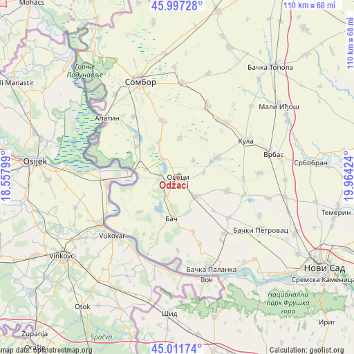
Odžaci GPS coordinates[2]
45° 30' 24.012" North, 19° 15' 39.996" East
| Map corner | latitude | longitude |
|---|---|---|
| Upper-left | 45.99728°, | 18.55799° |
| Center: | 45.50667°, | 19.26111° |
| Lower-right: | 45.01174°, | 19.96424° |
| Map W x H: | 109.6×109.6 km | = 68.1×68.1mi |
| max Lat: | 46.1° ⇑14.7% North |
| Odžaci: | 45.50667° |
| min Lat: | ⇓85.3% South 42.25846° |
| min Long | Odžaci | max Long |
| 18.9276° | 19.26111° | 22.77556° |
| W 3.4%⇐ | ⇒96.6% E |
Elevation
Elevation of Odžaci is 89 m = 292 ft, and this is 87.4 m = 287 ft below average elevation for this country.
| Max E: |
1421 m = 4662 ft | 49.4% |
| Avg. | 176.4 m = 579 ft | |
| Odžaci | 89 m = 292 ft | |
Min E: |
49 m = 161 ft | 50.6% |
See also: Serbia elevation on elevation.city.
Geographical zone
Odžaci is located in North temperate zone (between Tropic of Cancer and the Arctic Circle). Distance of this North polar circle is 2341.3 km =1454.8 mi to North.| Distance of | km | miles | from Odžaci |
|---|---|---|---|
| North Pole | 4947.2 | 3074 | to North |
| Arctic Circle | 2341.3 | 1454.8 | to North |
| Tropic Cancer | 2453.9 | 1524.8 | to South |
| Equator | 5059.9 | 3144.1 | to South |


Nearby cities:
15 places around Odžaci: (largest is in red/bold)
• Apatin
28.7 km =17.8 mi,  309°
309°
• Bač
12.9 km =8 mi,  188°
188°
• Bačka Palanka
30.5 km =19 mi,  159°
159°
• Bački Petrovac
30.5 km =19 mi,  122°
122°
• Bogojevo
10.5 km =6.5 mi,  284°
284°
• Despotovo
21.3 km =13.2 mi,  104°
104°
• Doroslovo
12.5 km =7.8 mi,  333°
333°
• Kula
23.6 km =14.7 mi,  61°
61°
• Kulpin
28 km =17.4 mi,  114°
114°
• Maglić
26.5 km =16.5 mi,  127°
127°
• Obrovac
21.8 km =13.5 mi, 161°
• Prigrevica
23.2 km =14.4 mi,  324°
324°
• Ravno Selo
28.8 km =17.9 mi, 102°
• Sonta
16.1 km =10 mi, 307°
• Vrbas
30.4 km =18.9 mi,  76°
76°
Sources, notices
• [Note1] Compared only with cities in Serbia existing in our database
• [Src1] Map data: © OpenStreetMap contributors (CC-BY-SA)
• [Src2] Other city data from geonames.org with taken over terms of usage.
• [Src3] Geographical zone / Annual Mean Temperature by Robert A. Rohde @ Wikipedia
