Prigrevica geodata
Prigrevica (Vojvodina) is a populated place; located in Serbia in Europe/Belgrade (GMT+2) time zone. With population of 5,026 people, there are 91 cities with bigger population in this country. Compared to other cities in Serbia, 91.2% of cities are located further ↓South; 98.9% of cities are located further →East and 54.9% of cities have higher elevation than Prigrevica. Note1


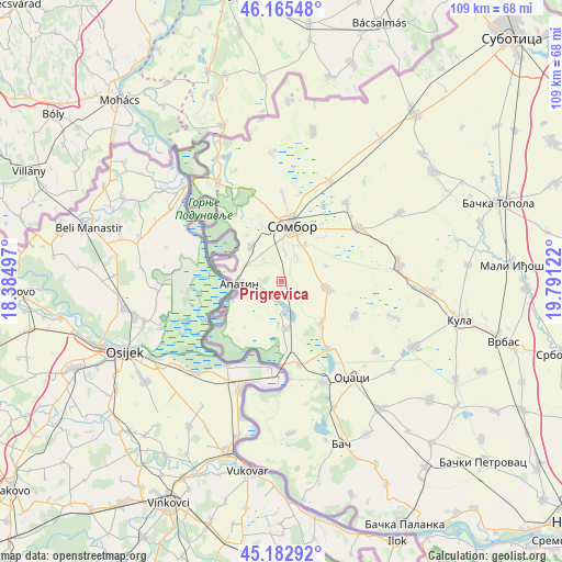
Prigrevica GPS coordinates[2]
45° 40' 34.896" North, 19° 5' 17.124" East
| Map corner | latitude | longitude |
|---|---|---|
| Upper-left | 46.16548°, | 18.38497° |
| Center: | 45.67636°, | 19.08809° |
| Lower-right: | 45.18292°, | 19.79122° |
| Map W x H: | 109.3×109.2 km | = 67.9×67.9mi |
| max Lat: | 46.1° ⇑8.8% North |
| Prigrevica: | 45.67636° |
| min Lat: | ⇓91.2% South 42.25846° |
| min Long | Prigrevica | max Long |
| 18.9276° | 19.08809° | 22.77556° |
| W 1.1%⇐ | ⇒98.9% E |
Elevation
Elevation of Prigrevica is 85 m = 279 ft, and this is 91.4 m = 300 ft below average elevation for this country.
| Max E: |
1421 m = 4662 ft | 54.9% |
| Avg. | 176.4 m = 579 ft | |
| Prigrevica | 85 m = 279 ft | |
Min E: |
49 m = 161 ft | 45.1% |
See also: Serbia elevation on elevation.city.
Geographical zone
Prigrevica is located in North temperate zone (between Tropic of Cancer and the Arctic Circle). Distance of this North polar circle is 2322.4 km =1443.1 mi to North.| Distance of | km | miles | from Prigrevica |
|---|---|---|---|
| North Pole | 4928.3 | 3062.3 | to North |
| Arctic Circle | 2322.4 | 1443.1 | to North |
| Tropic Cancer | 2472.8 | 1536.5 | to South |
| Equator | 5078.7 | 3155.8 | to South |


Nearby cities:
15 places around Prigrevica: (largest is in red/bold)
• Apatin
8.6 km =5.3 mi,  267°
267°
• Bač
33.7 km =20.9 mi,  159°
159°
• Bački Breg
29.8 km =18.5 mi,  335°
335°
• Bogojevo
16.6 km =10.3 mi,  168°
168°
• Despotovo
41.8 km =26 mi,  125°
125°
• Doroslovo
11 km =6.8 mi, 134°
• Gakovo
25 km =15.5 mi,  355°
355°
• Kolut
27.1 km =16.8 mi,  332°
332°
• Kula
34.9 km =21.7 mi,  102°
102°
• Kupusina
9.1 km =5.7 mi,  318°
318°
• Odžaci
23.2 km =14.4 mi,  144°
144°
• Riđica
35 km =21.7 mi,  2°
2°
• Sombor
11 km =6.8 mi,  9°
9°
• Sonta
9.2 km =5.7 mi,  175°
175°
• Stanišić
29.8 km =18.5 mi, 11°
Sources, notices
• [Note1] Compared only with cities in Serbia existing in our database
• [Src1] Map data: © OpenStreetMap contributors (CC-BY-SA)
• [Src2] Other city data from geonames.org with taken over terms of usage.
• [Src3] Geographical zone / Annual Mean Temperature by Robert A. Rohde @ Wikipedia
