Bor geodata
Bor (Central Serbia) is a seat of a second-order administrative division; located in Serbia in Europe/Belgrade (GMT+2) time zone. With population of 39,387 people, there are 24 cities with bigger population in this country. Compared to other cities in Serbia, 78.5% of cities are located further ↑North; 96.1% of cities are located further ←West and 90.7% of cities have lower elevation than Bor. Note1


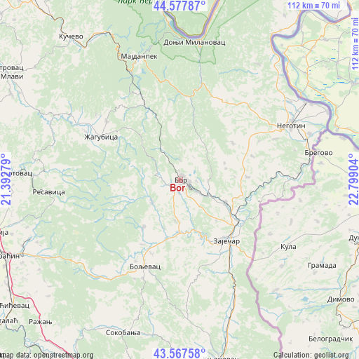
Bor GPS coordinates[2]
44° 4' 29.568" North, 22° 5' 45.276" East
| Map corner | latitude | longitude |
|---|---|---|
| Upper-left | 44.57787°, | 21.39279° |
| Center: | 44.07488°, | 22.09591° |
| Lower-right: | 43.56758°, | 22.79904° |
| Map W x H: | 112.3×112.3 km | = 69.8×69.8mi |
| max Lat: | 46.1° ⇑78.5% North |
| Bor: | 44.07488° |
| min Lat: | ⇓21.5% South 42.25846° |
| min Long | Bor | max Long |
| 18.9276° | 22.09591° | 22.77556° |
| W 96.1%⇐ | ⇒3.9% E |
Elevation
Elevation of Bor is 405 m = 1329 ft, and this is 228.6 m = 750 ft above average elevation for this country.
| Max E: |
1421 m = 4662 ft | 9.3% |
| Bor | 405 m 1329 ft | |
| Avg. | 176.4 m = 579 ft | |
Min E: |
49 m = 161 ft | 90.7% |
See also: Serbia elevation on elevation.city.
Geographical zone
Bor is located in North temperate zone (between Tropic of Cancer and the Arctic Circle). Distance of this Northern Tropic circle is 2294.7 km =1425.9 mi to South.| Distance of | km | miles | from Bor |
|---|---|---|---|
| North Pole | 5106.4 | 3173 | to North |
| Arctic Circle | 2500.5 | 1553.7 | to North |
| Tropic Cancer | 2294.7 | 1425.9 | to South |
| Equator | 4900.7 | 3045.2 | to South |


Nearby cities:
15 places around Bor: (largest is in red/bold)
• Boljevac
29.5 km =18.3 mi,  202°
202°
• Despotovac
51.9 km =32.2 mi,  272°
272°
• Donji Milanovac
43.7 km =27.2 mi,  5°
5°
• Duboka
56.5 km =35.1 mi,  331°
331°
• Knjazevac
58 km =36 mi,  167°
167°
• Kučevo
56.2 km =34.9 mi,  322°
322°
• Majdanpek
41 km =25.5 mi,  343°
343°
• Negotin
38.6 km =24 mi,  64°
64°
• Paraćin
60 km =37.3 mi,  246°
246°
• Soko Banja
51.3 km =31.9 mi, 200°
• Turija
61.6 km =38.3 mi, 323°
• Zaječar
23.3 km =14.5 mi,  144°
144°
• Ćuprija
60.3 km =37.5 mi, 254°
• Ševica
56.6 km =35.2 mi, 328°
• Žagubica
28 km =17.4 mi,  298°
298°
Sources, notices
• [Note1] Compared only with cities in Serbia existing in our database
• [Src1] Map data: © OpenStreetMap contributors (CC-BY-SA)
• [Src2] Other city data from geonames.org with taken over terms of usage.
• [Src3] Geographical zone / Annual Mean Temperature by Robert A. Rohde @ Wikipedia
