Ševica geodata
Ševica (Central Serbia) is a populated locality; located in Serbia in Europe/Belgrade (GMT+2) time zone. With population of 1,249 people, there are 290 cities with bigger population in this country. Compared to other cities in Serbia, 70.7% of cities are located further ↑North; 90% of cities are located further ←West and 77.6% of cities have lower elevation than Ševica. Note1


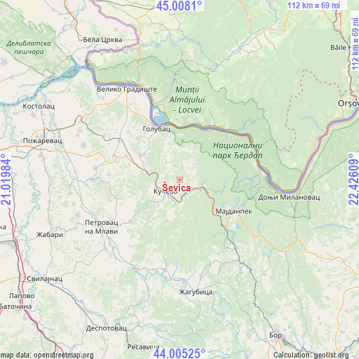
Ševica GPS coordinates[2]
44° 30' 31.788" North, 21° 43' 22.656" East
| Map corner | latitude | longitude |
|---|---|---|
| Upper-left | 45.0081°, | 21.01984° |
| Center: | 44.50883°, | 21.72296° |
| Lower-right: | 44.00525°, | 22.42609° |
| Map W x H: | 111.5×111.5 km | = 69.3×69.3mi |
| max Lat: | 46.1° ⇑70.7% North |
| Ševica: | 44.50883° |
| min Lat: | ⇓29.3% South 42.25846° |
| min Long | Ševica | max Long |
| 18.9276° | 21.72296° | 22.77556° |
| W 90%⇐ | ⇒10% E |
Elevation
Elevation of Ševica is 209 m = 686 ft, and this is 32.6 m = 107 ft above average elevation for this country.
| Max E: |
1421 m = 4662 ft | 22.4% |
| Ševica | 209 m 686 ft | |
| Avg. | 176.4 m = 579 ft | |
Min E: |
49 m = 161 ft | 77.6% |
See also: Serbia elevation on elevation.city.
Geographical zone
Ševica is located in North temperate zone (between Tropic of Cancer and the Arctic Circle). Distance of this Northern Tropic circle is 2343 km =1455.9 mi to South.| Distance of | km | miles | from Ševica |
|---|---|---|---|
| North Pole | 5058.1 | 3143 | to North |
| Arctic Circle | 2452.3 | 1523.8 | to North |
| Tropic Cancer | 2343 | 1455.9 | to South |
| Equator | 4948.9 | 3075.1 | to South |


Nearby cities:
15 places around Ševica: (largest is in red/bold)
• Bela Crkva
49.5 km =30.8 mi,  330°
330°
• Despotovac
51.2 km =31.8 mi,  205°
205°
• Donji Milanovac
34.3 km =21.3 mi,  97°
97°
• Duboka
3.3 km =2.1 mi,  63°
63°
• Golubac
17.6 km =10.9 mi,  335°
335°
• Kučevo
5.5 km =3.4 mi,  230°
230°
• Majdanpek
19.9 km =12.4 mi,  117°
117°
• Malo Crniće
35.1 km =21.8 mi,  278°
278°
• Petrovac
28.2 km =17.5 mi,  238°
238°
• Požarevac
44.2 km =27.5 mi,  286°
286°
• Radenka
8.9 km =5.5 mi,  21°
21°
• Turija
6.8 km =4.2 mi, 283°
• Veliko Gradište
32.7 km =20.3 mi, 329°
• Žabari
43.8 km =27.2 mi,  247°
247°
• Žagubica
35.1 km =21.8 mi,  171°
171°
Sources, notices
• [Note1] Compared only with cities in Serbia existing in our database
• [Src1] Map data: © OpenStreetMap contributors (CC-BY-SA)
• [Src2] Other city data from geonames.org with taken over terms of usage.
• [Src3] Geographical zone / Annual Mean Temperature by Robert A. Rohde @ Wikipedia
