Malo Crniće geodata
Malo Crniće (Central Serbia) is a seat of a third-order administrative division; located in Serbia in Europe/Belgrade (GMT+2) time zone. In our database, there are 365 cities with bigger population. Compared to other cities in Serbia, 67.8% of cities are located further ↑North; 81% of cities are located further ←West and 54.9% of cities have higher elevation than Malo Crniće. Note1


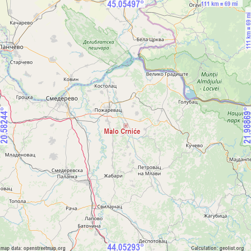
Malo Crniće GPS coordinates[2]
44° 33' 21.996" North, 21° 17' 8.016" East
| Map corner | latitude | longitude |
|---|---|---|
| Upper-left | 45.05497°, | 20.58244° |
| Center: | 44.55611°, | 21.28556° |
| Lower-right: | 44.05293°, | 21.98869° |
| Map W x H: | 111.4×111.4 km | = 69.2×69.2mi |
| max Lat: | 46.1° ⇑67.8% North |
| Malo Crniće: | 44.55611° |
| min Lat: | ⇓32.2% South 42.25846° |
| min Long | Malo Crniće | max Long |
| 18.9276° | 21.28556° | 22.77556° |
| W 81%⇐ | ⇒19% E |
Elevation
Elevation of Malo Crniće is 85 m = 279 ft, and this is 91.4 m = 300 ft below average elevation for this country.
| Max E: |
1421 m = 4662 ft | 54.9% |
| Avg. | 176.4 m = 579 ft | |
| Malo Crniće | 85 m = 279 ft | |
Min E: |
49 m = 161 ft | 45.1% |
See also: Serbia elevation on elevation.city.
Geographical zone
Malo Crniće is located in North temperate zone (between Tropic of Cancer and the Arctic Circle). Distance of this Northern Tropic circle is 2348.3 km =1459.2 mi to South.| Distance of | km | miles | from Malo Crniće |
|---|---|---|---|
| North Pole | 5052.9 | 3139.7 | to North |
| Arctic Circle | 2447 | 1520.5 | to North |
| Tropic Cancer | 2348.3 | 1459.2 | to South |
| Equator | 4954.2 | 3078.4 | to South |


Nearby cities:
15 places around Malo Crniće: (largest is in red/bold)
• Duboka
37.8 km =23.5 mi,  95°
95°
• Golubac
29.5 km =18.3 mi,  68°
68°
• Kovin
32.4 km =20.1 mi,  311°
311°
• Kučevo
31.7 km =19.7 mi,  106°
106°
• Lugavčina
17.4 km =10.8 mi,  257°
257°
• Petrovac
22.6 km =14 mi,  151°
151°
• Požarevac
10.6 km =6.6 mi, 313°
• Smederevo
30.8 km =19.1 mi,  293°
293°
• Smederevska Palanka
33.5 km =20.8 mi,  230°
230°
• Svilajnac
36.5 km =22.7 mi,  191°
191°
• Turija
28.3 km =17.6 mi, 97°
• Velika Plana
29.8 km =18.5 mi,  213°
213°
• Veliko Gradište
29.4 km =18.3 mi,  38°
38°
• Ševica
35.1 km =21.8 mi, 98°
• Žabari
22.9 km =14.2 mi, 194°
Sources, notices
• [Note1] Compared only with cities in Serbia existing in our database
• [Src1] Map data: © OpenStreetMap contributors (CC-BY-SA)
• [Src2] Other city data from geonames.org with taken over terms of usage.
• [Src3] Geographical zone / Annual Mean Temperature by Robert A. Rohde @ Wikipedia
