Golubac geodata
Golubac (Central Serbia) is a seat of a third-order administrative division; located in Serbia in Europe/Belgrade (GMT+2) time zone. With population of 1,655 people, there are 246 cities with bigger population in this country. Compared to other cities in Serbia, 62.4% of cities are located further ↑North; 87.5% of cities are located further ←West and 97.5% of cities have higher elevation than Golubac. Note1


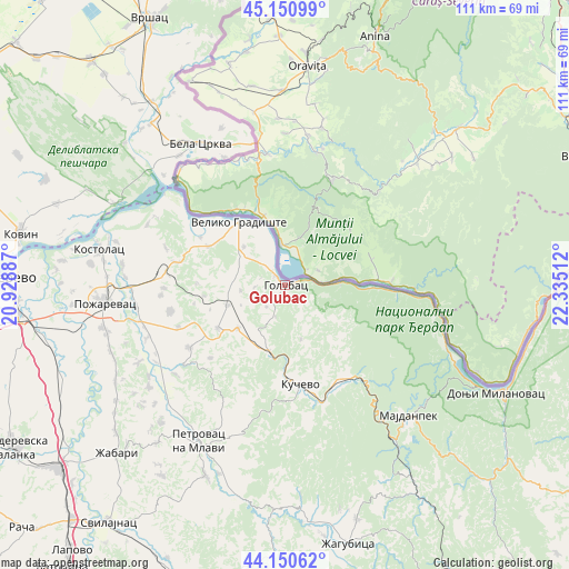
Golubac GPS coordinates[2]
44° 39' 10.656" North, 21° 37' 55.164" East
| Map corner | latitude | longitude |
|---|---|---|
| Upper-left | 45.15099°, | 20.92887° |
| Center: | 44.65296°, | 21.63199° |
| Lower-right: | 44.15062°, | 22.33512° |
| Map W x H: | 111.2×111.2 km | = 69.1×69.1mi |
| max Lat: | 46.1° ⇑62.4% North |
| Golubac: | 44.65296° |
| min Lat: | ⇓37.6% South 42.25846° |
| min Long | Golubac | max Long |
| 18.9276° | 21.63199° | 22.77556° |
| W 87.5%⇐ | ⇒12.5% E |
Elevation
Elevation of Golubac is 73 m = 240 ft, and this is 103.4 m = 339 ft below average elevation for this country.
| Max E: |
1421 m = 4662 ft | 97.5% |
| Avg. | 176.4 m = 579 ft | |
| Golubac | 73 m = 240 ft | |
Min E: |
49 m = 161 ft | 2.5% |
See also: Serbia elevation on elevation.city.
Geographical zone
Golubac is located in North temperate zone (between Tropic of Cancer and the Arctic Circle). Distance of this Northern Tropic circle is 2359 km =1465.8 mi to South.| Distance of | km | miles | from Golubac |
|---|---|---|---|
| North Pole | 5042.1 | 3133 | to North |
| Arctic Circle | 2436.2 | 1513.8 | to North |
| Tropic Cancer | 2359 | 1465.8 | to South |
| Equator | 4964.9 | 3085 | to South |


Nearby cities:
15 places around Golubac: (largest is in red/bold)
• Bela Crkva
32 km =19.9 mi,  328°
328°
• Donji Milanovac
46.1 km =28.6 mi,  116°
116°
• Duboka
17.7 km =11 mi,  145°
145°
• Kučevo
19.7 km =12.2 mi,  171°
171°
• Lugavčina
46.7 km =29 mi,  252°
252°
• Majdanpek
35.3 km =21.9 mi,  135°
135°
• Malo Crniće
29.5 km =18.3 mi, 248°
• Petrovac
35 km =21.7 mi,  208°
208°
• Požarevac
35.3 km =21.9 mi,  264°
264°
• Radenka
13 km =8.1 mi,  126°
126°
• Turija
14.5 km =9 mi,  177°
177°
• Veliko Gradište
15.3 km =9.5 mi,  323°
323°
• Vojvodinci
46.1 km =28.6 mi, 330°
• Ševica
17.6 km =10.9 mi,  155°
155°
• Žabari
46.7 km =29 mi,  225°
225°
Sources, notices
• [Note1] Compared only with cities in Serbia existing in our database
• [Src1] Map data: © OpenStreetMap contributors (CC-BY-SA)
• [Src2] Other city data from geonames.org with taken over terms of usage.
• [Src3] Geographical zone / Annual Mean Temperature by Robert A. Rohde @ Wikipedia
