Radenka geodata
Radenka (Central Serbia) is a populated place; located in Serbia in Europe/Belgrade (GMT+2) time zone. With population of 1,541 people, there are 257 cities with bigger population in this country. Compared to other cities in Serbia, 66% of cities are located further ↑North; 92.5% of cities are located further ←West and 88.2% of cities have lower elevation than Radenka. Note1


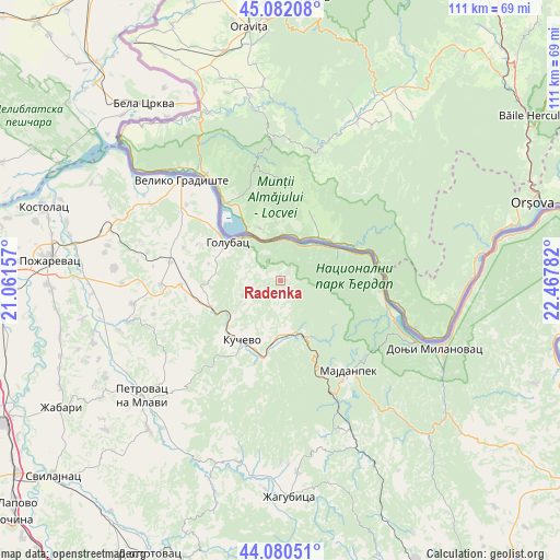
Radenka GPS coordinates[2]
44° 35' 0.42" North, 21° 45' 52.884" East
| Map corner | latitude | longitude |
|---|---|---|
| Upper-left | 45.08208°, | 21.06157° |
| Center: | 44.58345°, | 21.76469° |
| Lower-right: | 44.08051°, | 22.46782° |
| Map W x H: | 111.4×111.4 km | = 69.2×69.2mi |
| max Lat: | 46.1° ⇑66% North |
| Radenka: | 44.58345° |
| min Lat: | ⇓34% South 42.25846° |
| min Long | Radenka | max Long |
| 18.9276° | 21.76469° | 22.77556° |
| W 92.5%⇐ | ⇒7.5% E |
Elevation
Elevation of Radenka is 364 m = 1194 ft, and this is 187.6 m = 615 ft above average elevation for this country.
| Max E: |
1421 m = 4662 ft | 11.8% |
| Radenka | 364 m 1194 ft | |
| Avg. | 176.4 m = 579 ft | |
Min E: |
49 m = 161 ft | 88.2% |
See also: Serbia elevation on elevation.city.
Geographical zone
Radenka is located in North temperate zone (between Tropic of Cancer and the Arctic Circle). Distance of this Northern Tropic circle is 2351.3 km =1461 mi to South.| Distance of | km | miles | from Radenka |
|---|---|---|---|
| North Pole | 5049.8 | 3137.8 | to North |
| Arctic Circle | 2444 | 1518.6 | to North |
| Tropic Cancer | 2351.3 | 1461 | to South |
| Equator | 4957.2 | 3080.3 | to South |


Nearby cities:
15 places around Radenka: (largest is in red/bold)
• Bela Crkva
44.4 km =27.6 mi,  321°
321°
• Donji Milanovac
33.3 km =20.7 mi,  113°
113°
• Duboka
6.8 km =4.2 mi,  182°
182°
• Golubac
13 km =8.1 mi,  306°
306°
• Kučevo
14 km =8.7 mi,  212°
212°
• Lugavčina
55.4 km =34.4 mi,  263°
263°
• Majdanpek
22.5 km =14 mi,  140°
140°
• Malo Crniće
38.1 km =23.7 mi,  265°
265°
• Petrovac
35.8 km =22.2 mi,  230°
230°
• Požarevac
45.9 km =28.5 mi,  275°
275°
• Turija
12 km =7.5 mi,  235°
235°
• Veliko Gradište
28 km =17.4 mi, 315°
• Ševica
8.9 km =5.5 mi,  201°
201°
• Žabari
50.4 km =31.3 mi, 239°
• Žagubica
43 km =26.7 mi, 177°
Sources, notices
• [Note1] Compared only with cities in Serbia existing in our database
• [Src1] Map data: © OpenStreetMap contributors (CC-BY-SA)
• [Src2] Other city data from geonames.org with taken over terms of usage.
• [Src3] Geographical zone / Annual Mean Temperature by Robert A. Rohde @ Wikipedia
