Lugavčina geodata
Lugavčina (Central Serbia) is a populated place; located in Serbia in Europe/Belgrade (GMT+2) time zone. With population of 3,300 people, there are 135 cities with bigger population in this country. Compared to other cities in Serbia, 69.4% of cities are located further ↑North; 76.4% of cities are located further ←West and 60.1% of cities have higher elevation than Lugavčina. Note1


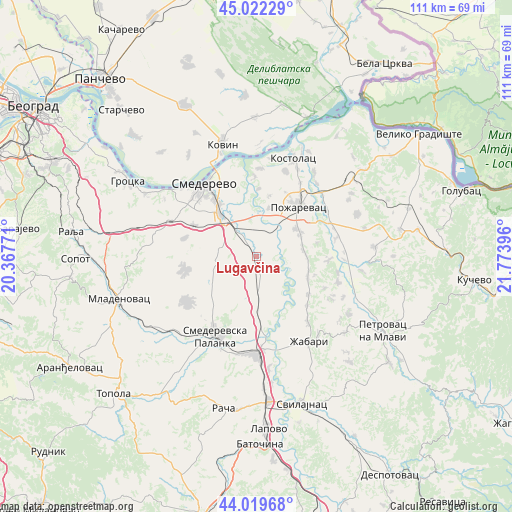
Lugavčina GPS coordinates[2]
44° 31' 23.304" North, 21° 4' 14.988" East
| Map corner | latitude | longitude |
|---|---|---|
| Upper-left | 45.02229°, | 20.36771° |
| Center: | 44.52314°, | 21.07083° |
| Lower-right: | 44.01968°, | 21.77396° |
| Map W x H: | 111.5×111.5 km | = 69.3×69.3mi |
| max Lat: | 46.1° ⇑69.4% North |
| Lugavčina: | 44.52314° |
| min Lat: | ⇓30.6% South 42.25846° |
| min Long | Lugavčina | max Long |
| 18.9276° | 21.07083° | 22.77556° |
| W 76.4%⇐ | ⇒23.6% E |
Elevation
Elevation of Lugavčina is 82 m = 269 ft, and this is 94.4 m = 310 ft below average elevation for this country.
| Max E: |
1421 m = 4662 ft | 60.1% |
| Avg. | 176.4 m = 579 ft | |
| Lugavčina | 82 m = 269 ft | |
Min E: |
49 m = 161 ft | 39.9% |
See also: Serbia elevation on elevation.city.
Geographical zone
Lugavčina is located in North temperate zone (between Tropic of Cancer and the Arctic Circle). Distance of this Northern Tropic circle is 2344.6 km =1456.9 mi to South.| Distance of | km | miles | from Lugavčina |
|---|---|---|---|
| North Pole | 5056.6 | 3142 | to North |
| Arctic Circle | 2450.7 | 1522.8 | to North |
| Tropic Cancer | 2344.6 | 1456.9 | to South |
| Equator | 4950.5 | 3076.1 | to South |


Nearby cities:
15 places around Lugavčina: (largest is in red/bold)
• Batočina
41.1 km =25.5 mi,  178°
178°
• Grocka
32.5 km =20.2 mi,  300°
300°
• Kovin
26 km =16.2 mi,  343°
343°
• Lapovo
37.7 km =23.4 mi, 176°
• Malo Crniće
17.4 km =10.8 mi,  77°
77°
• Mladenovac
30.9 km =19.2 mi,  252°
252°
• Petrovac
32.1 km =19.9 mi,  120°
120°
• Požarevac
14.3 km =8.9 mi,  40°
40°
• Rača
33.7 km =20.9 mi,  192°
192°
• Smederevo
19.4 km =12.1 mi,  324°
324°
• Smederevska Palanka
19.7 km =12.2 mi,  206°
206°
• Sopot
39.4 km =24.5 mi,  269°
269°
• Svilajnac
33.7 km =20.9 mi,  162°
162°
• Velika Plana
21 km =13 mi, 178°
• Žabari
21.8 km =13.5 mi,  148°
148°
Sources, notices
• [Note1] Compared only with cities in Serbia existing in our database
• [Src1] Map data: © OpenStreetMap contributors (CC-BY-SA)
• [Src2] Other city data from geonames.org with taken over terms of usage.
• [Src3] Geographical zone / Annual Mean Temperature by Robert A. Rohde @ Wikipedia
