Kovin geodata
Kovin (Vojvodina) is a seat of a third-order administrative division; located in Serbia in Europe/Belgrade (GMT+2) time zone. With population of 14,250 people, there are 48 cities with bigger population in this country. Compared to other cities in Serbia, 56.5% of cities are located further ↑North; 73.9% of cities are located further ←West and 78.9% of cities have higher elevation than Kovin. Note1


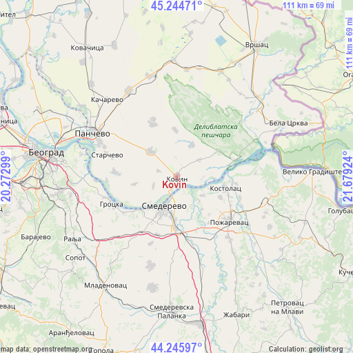
Kovin GPS coordinates[2]
44° 44' 51" North, 20° 58' 33.996" East
| Map corner | latitude | longitude |
|---|---|---|
| Upper-left | 45.24471°, | 20.27299° |
| Center: | 44.7475°, | 20.97611° |
| Lower-right: | 44.24597°, | 21.67924° |
| Map W x H: | 111×111 km | = 69×69mi |
| max Lat: | 46.1° ⇑56.5% North |
| Kovin: | 44.7475° |
| min Lat: | ⇓43.5% South 42.25846° |
| min Long | Kovin | max Long |
| 18.9276° | 20.97611° | 22.77556° |
| W 73.9%⇐ | ⇒26.1% E |
Elevation
Elevation of Kovin is 78 m = 256 ft, and this is 98.4 m = 323 ft below average elevation for this country.
| Max E: |
1421 m = 4662 ft | 78.9% |
| Avg. | 176.4 m = 579 ft | |
| Kovin | 78 m = 256 ft | |
Min E: |
49 m = 161 ft | 21.1% |
See also: Serbia elevation on elevation.city.
Geographical zone
Kovin is located in North temperate zone (between Tropic of Cancer and the Arctic Circle). Distance of this Northern Tropic circle is 2369.5 km =1472.3 mi to South.| Distance of | km | miles | from Kovin |
|---|---|---|---|
| North Pole | 5031.6 | 3126.5 | to North |
| Arctic Circle | 2425.7 | 1507.3 | to North |
| Tropic Cancer | 2369.5 | 1472.3 | to South |
| Equator | 4975.5 | 3091.6 | to South |


Nearby cities:
15 places around Kovin: (largest is in red/bold)
• Alibunar
37.1 km =23.1 mi,  358°
358°
• Banatski Karlovac
33.8 km =21 mi,  5°
5°
• Grocka
22.2 km =13.8 mi,  247°
247°
• Izbište
34.7 km =21.6 mi,  28°
28°
• Lugavčina
26 km =16.2 mi,  163°
163°
• Malo Crniće
32.4 km =20.1 mi,  131°
131°
• Nikolinci
34.7 km =21.6 mi, 11°
• Ovča
38.1 km =23.7 mi,  293°
293°
• Palilula
37 km =23 mi,  281°
281°
• Pančevo
29.8 km =18.5 mi,  297°
297°
• Požarevac
21.8 km =13.5 mi, 129°
• Smederevo
10 km =6.2 mi,  202°
202°
• Uljma
35.6 km =22.1 mi,  23°
23°
• Vladimirovac
32.7 km =20.3 mi,  344°
344°
• Zvezdara
35.2 km =21.9 mi,  274°
274°
Sources, notices
• [Note1] Compared only with cities in Serbia existing in our database
• [Src1] Map data: © OpenStreetMap contributors (CC-BY-SA)
• [Src2] Other city data from geonames.org with taken over terms of usage.
• [Src3] Geographical zone / Annual Mean Temperature by Robert A. Rohde @ Wikipedia
