Svilajnac geodata
Svilajnac (Central Serbia) is a seat of a third-order administrative division; located in Serbia in Europe/Belgrade (GMT+2) time zone. In our database, there are 365 cities with bigger population. Compared to other cities in Serbia, 76.4% of cities are located further ↑North; 79.4% of cities are located further ←West and 56.7% of cities have lower elevation than Svilajnac. Note1


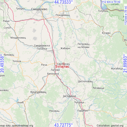
Svilajnac GPS coordinates[2]
44° 14' 1.32" North, 21° 11' 48.12" East
| Map corner | latitude | longitude |
|---|---|---|
| Upper-left | 44.73533°, | 20.49358° |
| Center: | 44.2337°, | 21.1967° |
| Lower-right: | 43.72775°, | 21.89983° |
| Map W x H: | 112×112 km | = 69.6×69.6mi |
| max Lat: | 46.1° ⇑76.4% North |
| Svilajnac: | 44.2337° |
| min Lat: | ⇓23.6% South 42.25846° |
| min Long | Svilajnac | max Long |
| 18.9276° | 21.1967° | 22.77556° |
| W 79.4%⇐ | ⇒20.6% E |
Elevation
Elevation of Svilajnac is 104 m = 341 ft, and this is 72.4 m = 238 ft below average elevation for this country.
| Max E: |
1421 m = 4662 ft | 43.3% |
| Avg. | 176.4 m = 579 ft | |
| Svilajnac | 104 m = 341 ft | |
Min E: |
49 m = 161 ft | 56.7% |
See also: Serbia elevation on elevation.city.
Geographical zone
Svilajnac is located in North temperate zone (between Tropic of Cancer and the Arctic Circle). Distance of this Northern Tropic circle is 2312.4 km =1436.9 mi to South.| Distance of | km | miles | from Svilajnac |
|---|---|---|---|
| North Pole | 5088.7 | 3162 | to North |
| Arctic Circle | 2482.8 | 1542.7 | to North |
| Tropic Cancer | 2312.4 | 1436.9 | to South |
| Equator | 4918.3 | 3056.1 | to South |


Nearby cities:
15 places around Svilajnac: (largest is in red/bold)
• Batočina
12.8 km =8 mi,  225°
225°
• Despotovac
25.4 km =15.8 mi,  128°
128°
• Glogovac
23.2 km =14.4 mi,  156°
156°
• Jagodina
29 km =18 mi,  169°
169°
• Kragujevac
32.9 km =20.4 mi,  222°
222°
• Lapovo
9.6 km =6 mi,  235°
235°
• Lugavčina
33.7 km =20.9 mi,  342°
342°
• Malo Crniće
36.5 km =22.7 mi,  11°
11°
• Petrovac
23.8 km =14.8 mi,  48°
48°
• Rača
17.5 km =10.9 mi,  267°
267°
• Smederevska Palanka
23.9 km =14.9 mi,  307°
307°
• Topola
41 km =25.5 mi, 273°
• Velika Plana
14.7 km =9.1 mi,  319°
319°
• Ćuprija
36.8 km =22.9 mi, 157°
• Žabari
13.7 km =8.5 mi, 6°
Sources, notices
• [Note1] Compared only with cities in Serbia existing in our database
• [Src1] Map data: © OpenStreetMap contributors (CC-BY-SA)
• [Src2] Other city data from geonames.org with taken over terms of usage.
• [Src3] Geographical zone / Annual Mean Temperature by Robert A. Rohde @ Wikipedia
