Ljig geodata
Ljig (Central Serbia) is a seat of a third-order administrative division; located in Serbia in Europe/Belgrade (GMT+2) time zone. With population of 2,979 people, there are 151 cities with bigger population in this country. Compared to other cities in Serbia, 76.6% of cities are located further ↑North; 56.2% of cities are located further →East and 69.8% of cities have lower elevation than Ljig. Note1


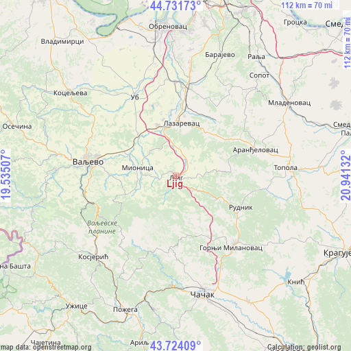
Ljig GPS coordinates[2]
44° 13' 48.252" North, 20° 14' 17.484" East
| Map corner | latitude | longitude |
|---|---|---|
| Upper-left | 44.73173°, | 19.53507° |
| Center: | 44.23007°, | 20.23819° |
| Lower-right: | 43.72409°, | 20.94132° |
| Map W x H: | 112×112 km | = 69.6×69.6mi |
| max Lat: | 46.1° ⇑76.6% North |
| Ljig: | 44.23007° |
| min Lat: | ⇓23.4% South 42.25846° |
| min Long | Ljig | max Long |
| 18.9276° | 20.23819° | 22.77556° |
| W 43.8%⇐ | ⇒56.2% E |
Elevation
Elevation of Ljig is 154 m = 505 ft, and this is 22.4 m = 73 ft below average elevation for this country.
| Max E: |
1421 m = 4662 ft | 30.2% |
| Avg. | 176.4 m = 579 ft | |
| Ljig | 154 m = 505 ft | |
Min E: |
49 m = 161 ft | 69.8% |
See also: Serbia elevation on elevation.city.
Geographical zone
Ljig is located in North temperate zone (between Tropic of Cancer and the Arctic Circle). Distance of this Northern Tropic circle is 2312 km =1436.6 mi to South.| Distance of | km | miles | from Ljig |
|---|---|---|---|
| North Pole | 5089.1 | 3162.2 | to North |
| Arctic Circle | 2483.3 | 1543.1 | to North |
| Tropic Cancer | 2312 | 1436.6 | to South |
| Equator | 4917.9 | 3055.8 | to South |


Nearby cities:
15 places around Ljig: (largest is in red/bold)
• Aranđelovac
27 km =16.8 mi,  71°
71°
• Barajevo
41.3 km =25.7 mi,  19°
19°
• Gornja Bukovica
35.9 km =22.3 mi,  289°
289°
• Gornji Milanovac
28.9 km =18 mi,  141°
141°
• Kosjerić
37.1 km =23.1 mi,  225°
225°
• Lajkovac
16.5 km =10.3 mi,  339°
339°
• Lazarevac
17.3 km =10.7 mi,  4°
4°
• Mionica
12.7 km =7.9 mi,  281°
281°
• Prislonica
34.7 km =21.6 mi,  153°
153°
• Stepojevac
31.8 km =19.8 mi,  8°
8°
• Stubline
39.2 km =24.4 mi,  347°
347°
• Topola
35.5 km =22.1 mi,  85°
85°
• Ub
28.3 km =17.6 mi,  332°
332°
• Valjevo
27.5 km =17.1 mi, 280°
• Čačak
38.7 km =24 mi,  166°
166°
Sources, notices
• [Note1] Compared only with cities in Serbia existing in our database
• [Src1] Map data: © OpenStreetMap contributors (CC-BY-SA)
• [Src2] Other city data from geonames.org with taken over terms of usage.
• [Src3] Geographical zone / Annual Mean Temperature by Robert A. Rohde @ Wikipedia
