Lapovo geodata
Lapovo (Central Serbia) is a seat of a third-order administrative division; located in Serbia in Europe/Belgrade (GMT+2) time zone. With population of 7,422 people, there are 66 cities with bigger population in this country. Compared to other cities in Serbia, 77.8% of cities are located further ↑North; 77.6% of cities are located further ←West and 58.7% of cities have lower elevation than Lapovo. Note1


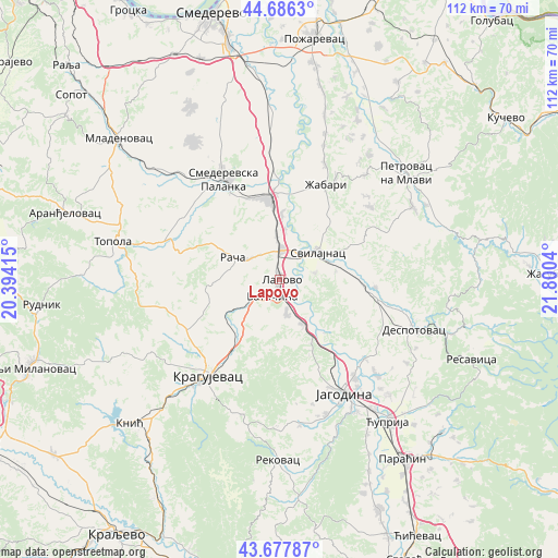
Lapovo GPS coordinates[2]
44° 11' 3.264" North, 21° 5' 50.172" East
| Map corner | latitude | longitude |
|---|---|---|
| Upper-left | 44.6863°, | 20.39415° |
| Center: | 44.18424°, | 21.09727° |
| Lower-right: | 43.67787°, | 21.8004° |
| Map W x H: | 112.1×112.1 km | = 69.7×69.7mi |
| max Lat: | 46.1° ⇑77.8% North |
| Lapovo: | 44.18424° |
| min Lat: | ⇓22.2% South 42.25846° |
| min Long | Lapovo | max Long |
| 18.9276° | 21.09727° | 22.77556° |
| W 77.6%⇐ | ⇒22.4% E |
Elevation
Elevation of Lapovo is 110 m = 361 ft, and this is 66.4 m = 218 ft below average elevation for this country.
| Max E: |
1421 m = 4662 ft | 41.3% |
| Avg. | 176.4 m = 579 ft | |
| Lapovo | 110 m = 361 ft | |
Min E: |
49 m = 161 ft | 58.7% |
See also: Serbia elevation on elevation.city.
Geographical zone
Lapovo is located in North temperate zone (between Tropic of Cancer and the Arctic Circle). Distance of this Northern Tropic circle is 2306.9 km =1433.4 mi to South.| Distance of | km | miles | from Lapovo |
|---|---|---|---|
| North Pole | 5094.2 | 3165.4 | to North |
| Arctic Circle | 2488.3 | 1546.2 | to North |
| Tropic Cancer | 2306.9 | 1433.4 | to South |
| Equator | 4912.8 | 3052.7 | to South |


Nearby cities:
15 places around Lapovo: (largest is in red/bold)
• Batočina
3.6 km =2.2 mi,  200°
200°
• Despotovac
29.7 km =18.5 mi,  110°
110°
• Glogovac
23.4 km =14.5 mi,  132°
132°
• Jagodina
26.5 km =16.5 mi,  150°
150°
• Kragujevac
23.6 km =14.7 mi,  217°
217°
• Lugavčina
37.7 km =23.4 mi,  356°
356°
• Petrovac
33.4 km =20.8 mi,  50°
50°
• Rača
10.7 km =6.6 mi,  296°
296°
• Rekovac
35.7 km =22.2 mi,  180°
180°
• Smederevska Palanka
23 km =14.3 mi,  331°
331°
• Svilajnac
9.6 km =6 mi,  55°
55°
• Topola
34 km =21.1 mi,  283°
283°
• Velika Plana
16.7 km =10.4 mi,  354°
354°
• Ćuprija
35.9 km =22.3 mi,  142°
142°
• Žabari
21.3 km =13.2 mi,  26°
26°
Sources, notices
• [Note1] Compared only with cities in Serbia existing in our database
• [Src1] Map data: © OpenStreetMap contributors (CC-BY-SA)
• [Src2] Other city data from geonames.org with taken over terms of usage.
• [Src3] Geographical zone / Annual Mean Temperature by Robert A. Rohde @ Wikipedia
