Kragujevac geodata
Kragujevac (Central Serbia) is a seat of a second-order administrative division; located in Serbia in Europe/Belgrade (GMT+2) time zone. With population of 147,473 people, there are 4 cities with bigger population in this country. Compared to other cities in Serbia, 79.1% of cities are located further ↑North; 72.3% of cities are located further ←West and 74.4% of cities have lower elevation than Kragujevac. Note1


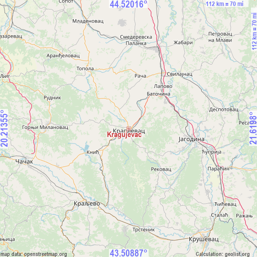
Kragujevac GPS coordinates[2]
44° 1' 0.012" North, 20° 55' 0.012" East
| Map corner | latitude | longitude |
|---|---|---|
| Upper-left | 44.52016°, | 20.21355° |
| Center: | 44.01667°, | 20.91667° |
| Lower-right: | 43.50887°, | 21.6198° |
| Map W x H: | 112.4×112.4 km | = 69.8×69.8mi |
| max Lat: | 46.1° ⇑79.1% North |
| Kragujevac: | 44.01667° |
| min Lat: | ⇓20.9% South 42.25846° |
| min Long | Kragujevac | max Long |
| 18.9276° | 20.91667° | 22.77556° |
| W 72.3%⇐ | ⇒27.7% E |
Elevation
Elevation of Kragujevac is 182 m = 597 ft, and this is 5.6 m = 18 ft above average elevation for this country.
| Max E: |
1421 m = 4662 ft | 25.6% |
| Kragujevac | 182 m 597 ft | |
| Avg. | 176.4 m = 579 ft | |
Min E: |
49 m = 161 ft | 74.4% |
See also: Kragujevac elevation on elevation.city.
Geographical zone
Kragujevac is located in North temperate zone (between Tropic of Cancer and the Arctic Circle). Distance of this Northern Tropic circle is 2288.3 km =1421.9 mi to South.| Distance of | km | miles | from Kragujevac |
|---|---|---|---|
| North Pole | 5112.9 | 3177 | to North |
| Arctic Circle | 2507 | 1557.8 | to North |
| Tropic Cancer | 2288.3 | 1421.9 | to South |
| Equator | 4894.2 | 3041.1 | to South |


Nearby cities:
15 places around Kragujevac: (largest is in red/bold)
• Batočina
20.1 km =12.5 mi,  40°
40°
• Donja Gorevnica
36.8 km =22.9 mi,  245°
245°
• Glogovac
31.8 km =19.8 mi,  84°
84°
• Gornji Milanovac
36.4 km =22.6 mi,  271°
271°
• Jagodina
27.9 km =17.3 mi,  99°
99°
• Knić
18.7 km =11.6 mi,  237°
237°
• Kraljevo
37.1 km =23.1 mi,  209°
209°
• Lapovo
23.6 km =14.7 mi, 37°
• Rača
23.9 km =14.9 mi,  11°
11°
• Rekovac
22.2 km =13.8 mi,  140°
140°
• Smederevska Palanka
38.9 km =24.2 mi,  4°
4°
• Svilajnac
32.9 km =20.4 mi, 42°
• Topola
32.4 km =20.1 mi,  324°
324°
• Velika Plana
37.5 km =23.3 mi,  19°
19°
• Ćuprija
37.6 km =23.4 mi,  105°
105°
Sources, notices
• [Note1] Compared only with cities in Serbia existing in our database
• [Src1] Map data: © OpenStreetMap contributors (CC-BY-SA)
• [Src2] Other city data from geonames.org with taken over terms of usage.
• [Src3] Geographical zone / Annual Mean Temperature by Robert A. Rohde @ Wikipedia
