Čačak geodata
Čačak (Central Serbia) is a seat of a second-order administrative division; located in Serbia in Europe/Belgrade (GMT+2) time zone. With population of 117,072 people, there are 5 cities with bigger population in this country. Compared to other cities in Serbia, 81% of cities are located further ↑North; 50.1% of cities are located further ←West and 80.3% of cities have lower elevation than Čačak. Note1


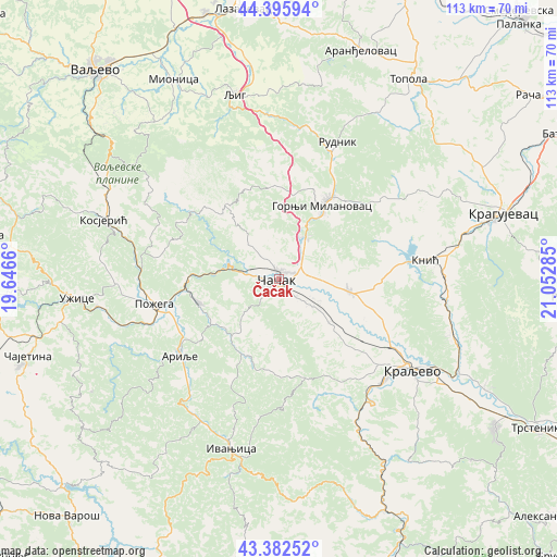
Čačak GPS coordinates[2]
43° 53' 29.004" North, 20° 20' 58.992" East
| Map corner | latitude | longitude |
|---|---|---|
| Upper-left | 44.39594°, | 19.6466° |
| Center: | 43.89139°, | 20.34972° |
| Lower-right: | 43.38252°, | 21.05285° |
| Map W x H: | 112.7×112.7 km | = 70×70mi |
| max Lat: | 46.1° ⇑81% North |
| Čačak: | 43.89139° |
| min Lat: | ⇓19% South 42.25846° |
| min Long | Čačak | max Long |
| 18.9276° | 20.34972° | 22.77556° |
| W 50.1%⇐ | ⇒49.9% E |
Elevation
Elevation of Čačak is 241 m = 791 ft, and this is 64.6 m = 212 ft above average elevation for this country.
| Max E: |
1421 m = 4662 ft | 19.7% |
| Čačak | 241 m 791 ft | |
| Avg. | 176.4 m = 579 ft | |
Min E: |
49 m = 161 ft | 80.3% |
See also: Čačak elevation on elevation.city.
Geographical zone
Čačak is located in North temperate zone (between Tropic of Cancer and the Arctic Circle). Distance of this Northern Tropic circle is 2274.3 km =1413.2 mi to South.| Distance of | km | miles | from Čačak |
|---|---|---|---|
| North Pole | 5126.8 | 3185.6 | to North |
| Arctic Circle | 2520.9 | 1566.4 | to North |
| Tropic Cancer | 2274.3 | 1413.2 | to South |
| Equator | 4880.3 | 3032.5 | to South |


Nearby cities:
15 places around Čačak: (largest is in red/bold)
• Arilje
25.5 km =15.8 mi,  232°
232°
• Brezovica
16.9 km =10.5 mi,  162°
162°
• Donja Gorevnica
12.2 km =7.6 mi,  97°
97°
• Gornji Milanovac
17.4 km =10.8 mi,  30°
30°
• Ivanjica
35.9 km =22.3 mi,  195°
195°
• Knić
29.8 km =18.5 mi,  82°
82°
• Kosjerić
37.3 km =23.2 mi,  288°
288°
• Kragujevac
47.5 km =29.5 mi,  72°
72°
• Kraljevo
32.9 km =20.4 mi,  124°
124°
• Ljig
38.7 km =24 mi,  346°
346°
• Lučani
17.3 km =10.7 mi,  258°
258°
• Mionica
45.4 km =28.2 mi,  331°
331°
• Požega
25.6 km =15.9 mi, 259°
• Prislonica
9.6 km =6 mi,  45°
45°
• Užice
40.3 km =25 mi, 264°
Sources, notices
• [Note1] Compared only with cities in Serbia existing in our database
• [Src1] Map data: © OpenStreetMap contributors (CC-BY-SA)
• [Src2] Other city data from geonames.org with taken over terms of usage.
• [Src3] Geographical zone / Annual Mean Temperature by Robert A. Rohde @ Wikipedia
