Užice geodata
Užice (Central Serbia) is a seat of a second-order administrative division; located in Serbia in Europe/Belgrade (GMT+2) time zone. With population of 63,577 people, there are 13 cities with bigger population in this country. Compared to other cities in Serbia, 82.1% of cities are located further ↑North; 71.2% of cities are located further →East and 91.4% of cities have lower elevation than Užice. Note1


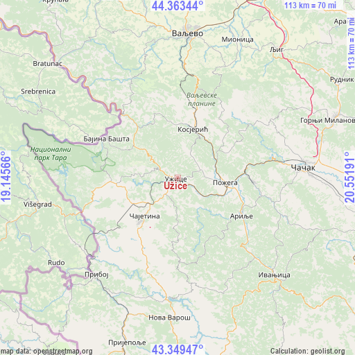
Užice GPS coordinates[2]
43° 51' 30.996" North, 19° 50' 55.608" East
| Map corner | latitude | longitude |
|---|---|---|
| Upper-left | 44.36344°, | 19.14566° |
| Center: | 43.85861°, | 19.84878° |
| Lower-right: | 43.34947°, | 20.55191° |
| Map W x H: | 112.7×112.7 km | = 70×70mi |
| max Lat: | 46.1° ⇑82.1% North |
| Užice: | 43.85861° |
| min Lat: | ⇓17.9% South 42.25846° |
| min Long | Užice | max Long |
| 18.9276° | 19.84878° | 22.77556° |
| W 28.8%⇐ | ⇒71.2% E |
Elevation
Elevation of Užice is 438 m = 1437 ft, and this is 261.6 m = 858 ft above average elevation for this country.
| Max E: |
1421 m = 4662 ft | 8.6% |
| Užice | 438 m 1437 ft | |
| Avg. | 176.4 m = 579 ft | |
Min E: |
49 m = 161 ft | 91.4% |
See also: Užice elevation on elevation.city.
Geographical zone
Užice is located in North temperate zone (between Tropic of Cancer and the Arctic Circle). Distance of this Northern Tropic circle is 2270.7 km =1410.9 mi to South.| Distance of | km | miles | from Užice |
|---|---|---|---|
| North Pole | 5130.4 | 3187.9 | to North |
| Arctic Circle | 2524.6 | 1568.7 | to North |
| Tropic Cancer | 2270.7 | 1410.9 | to South |
| Equator | 4876.6 | 3030.2 | to South |


Nearby cities:
15 places around Užice: (largest is in red/bold)
• Arilje
23 km =14.3 mi,  120°
120°
• Bajina Bašta
25.8 km =16 mi,  298°
298°
• Brezovica
47.1 km =29.3 mi,  105°
105°
• Ivanjica
43.6 km =27.1 mi,  135°
135°
• Kosjerić
16 km =9.9 mi,  16°
16°
• Lučani
23.2 km =14.4 mi,  89°
89°
• Mokra Gora
29 km =18 mi,  254°
254°
• Nova Varoš
44.4 km =27.6 mi,  183°
183°
• Požega
15.1 km =9.4 mi, 94°
• Priboj
40.2 km =25 mi,  220°
220°
• Valjevo
46.5 km =28.9 mi,  4°
4°
• Zlatibor
18.7 km =11.6 mi, 219°
• Ðurići
35.2 km =21.9 mi,  263°
263°
• Čajetina
16.3 km =10.1 mi, 222°
• Čačak
40.3 km =25 mi,  84°
84°
Sources, notices
• [Note1] Compared only with cities in Serbia existing in our database
• [Src1] Map data: © OpenStreetMap contributors (CC-BY-SA)
• [Src2] Other city data from geonames.org with taken over terms of usage.
• [Src3] Geographical zone / Annual Mean Temperature by Robert A. Rohde @ Wikipedia
