Gornji Milanovac geodata
Gornji Milanovac (Central Serbia) is a seat of a third-order administrative division; located in Serbia in Europe/Belgrade (GMT+2) time zone. With population of 23,982 people, there are 37 cities with bigger population in this country. Compared to other cities in Serbia, 78.9% of cities are located further ↑North; 56% of cities are located further ←West and 86.8% of cities have lower elevation than Gornji Milanovac. Note1
Administrative division(s):
- Level 1: Central Serbia
- Level 2: Morava
- Level 3: Opština Gornji Milanovac


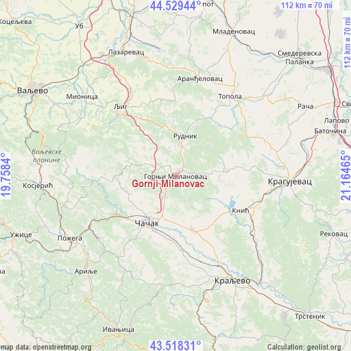
Gornji Milanovac GPS coordinates[2]
44° 1' 33.708" North, 20° 27' 41.472" East
| Map corner | latitude | longitude |
|---|---|---|
| Upper-left | 44.52944°, | 19.7584° |
| Center: | 44.02603°, | 20.46152° |
| Lower-right: | 43.51831°, | 21.16465° |
| Map W x H: | 112.4×112.4 km | = 69.8×69.8mi |
| max Lat: | 46.1° ⇑78.9% North |
| Gornji Milanovac: | 44.02603° |
| min Lat: | ⇓21.1% South 42.25846° |
| min Long | Gornji Milanova | max Long |
| 18.9276° | 20.46152° | 22.77556° |
| W 56%⇐ | ⇒44% E |
Elevation
Elevation of Gornji Milanovac is 326 m = 1070 ft, and this is 149.6 m = 491 ft above average elevation for this country.
| Max E: |
1421 m = 4662 ft | 13.2% |
| Gornji Milanovac | 326 m 1070 ft | |
| Avg. | 176.4 m = 579 ft | |
Min E: |
49 m = 161 ft | 86.8% |
See also: Serbia elevation on elevation.city.
Geographical zone
Gornji Milanovac is located in North temperate zone (between Tropic of Cancer and the Arctic Circle). Distance of this Northern Tropic circle is 2289.3 km =1422.5 mi to South.| Distance of | km | miles | from Gornji Milanovac |
|---|---|---|---|
| North Pole | 5111.8 | 3176.3 | to North |
| Arctic Circle | 2505.9 | 1557.1 | to North |
| Tropic Cancer | 2289.3 | 1422.5 | to South |
| Equator | 4895.2 | 3041.7 | to South |


Nearby cities:
15 places around Gornji Milanovac: (largest is in red/bold)
• Aranđelovac
32.2 km =20 mi,  14°
14°
• Arilje
42.2 km =26.2 mi,  224°
224°
• Brezovica
31.3 km =19.4 mi,  186°
186°
• Donja Gorevnica
16.9 km =10.5 mi,  169°
169°
• Knić
23.4 km =14.5 mi,  118°
118°
• Kragujevac
36.4 km =22.6 mi,  91°
91°
• Kraljevo
38.1 km =23.7 mi,  151°
151°
• Lazarevac
43.2 km =26.8 mi,  337°
337°
• Ljig
28.9 km =18 mi,  321°
321°
• Lučani
31.7 km =19.7 mi,  234°
234°
• Mionica
39.4 km =24.5 mi,  309°
309°
• Požega
39.3 km =24.4 mi,  239°
239°
• Prislonica
8.5 km =5.3 mi, 194°
• Topola
30.9 km =19.2 mi,  34°
34°
• Čačak
17.4 km =10.8 mi,  210°
210°
Sources, notices
• [Note1] Compared only with cities in Serbia existing in our database
• [Src1] Map data: © OpenStreetMap contributors (CC-BY-SA)
• [Src2] Other city data from geonames.org with taken over terms of usage.
• [Src3] Geographical zone / Annual Mean Temperature by Robert A. Rohde @ Wikipedia
