Požega geodata
Požega (Central Serbia) is a seat of a third-order administrative division; located in Serbia in Europe/Belgrade (GMT+2) time zone. In our database, there are 365 cities with bigger population. Compared to other cities in Serbia, 82.3% of cities are located further ↑North; 67.1% of cities are located further →East and 86.4% of cities have lower elevation than Požega. Note1


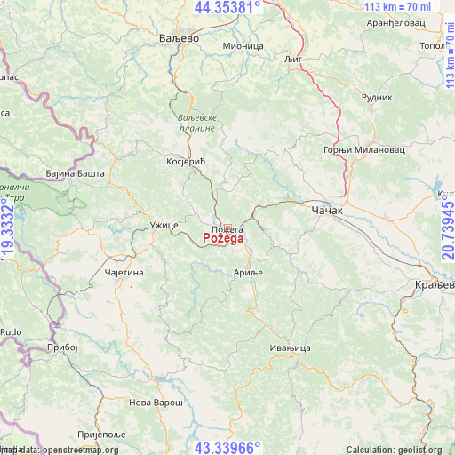
Požega GPS coordinates[2]
43° 50' 56.004" North, 20° 2' 10.752" East
| Map corner | latitude | longitude |
|---|---|---|
| Upper-left | 44.35381°, | 19.3332° |
| Center: | 43.84889°, | 20.03632° |
| Lower-right: | 43.33966°, | 20.73945° |
| Map W x H: | 112.8×112.8 km | = 70.1×70.1mi |
| max Lat: | 46.1° ⇑82.3% North |
| Požega: | 43.84889° |
| min Lat: | ⇓17.7% South 42.25846° |
| min Long | Požega | max Long |
| 18.9276° | 20.03632° | 22.77556° |
| W 32.9%⇐ | ⇒67.1% E |
Elevation
Elevation of Požega is 321 m = 1053 ft, and this is 144.6 m = 474 ft above average elevation for this country.
| Max E: |
1421 m = 4662 ft | 13.6% |
| Požega | 321 m 1053 ft | |
| Avg. | 176.4 m = 579 ft | |
Min E: |
49 m = 161 ft | 86.4% |
See also: Serbia elevation on elevation.city.
Geographical zone
Požega is located in North temperate zone (between Tropic of Cancer and the Arctic Circle). Distance of this Northern Tropic circle is 2269.6 km =1410.3 mi to South.| Distance of | km | miles | from Požega |
|---|---|---|---|
| North Pole | 5131.5 | 3188.6 | to North |
| Arctic Circle | 2525.6 | 1569.3 | to North |
| Tropic Cancer | 2269.6 | 1410.3 | to South |
| Equator | 4875.5 | 3029.5 | to South |


Nearby cities:
15 places around Požega: (largest is in red/bold)
• Arilje
11.7 km =7.3 mi,  155°
155°
• Bajina Bašta
39.9 km =24.8 mi,  289°
289°
• Brezovica
32.4 km =20.1 mi,  110°
110°
• Donja Gorevnica
37.3 km =23.2 mi,  85°
85°
• Gornji Milanovac
39.3 km =24.4 mi,  59°
59°
• Ivanjica
33.7 km =20.9 mi,  152°
152°
• Kosjerić
19.4 km =12.1 mi,  327°
327°
• Lučani
8.3 km =5.2 mi,  80°
80°
• Mionica
45 km =28 mi,  4°
4°
• Mokra Gora
43.5 km =27 mi,  261°
261°
• Prislonica
34 km =21.1 mi,  70°
70°
• Užice
15.1 km =9.4 mi,  274°
274°
• Zlatibor
30.1 km =18.7 mi,  243°
243°
• Čajetina
28.2 km =17.5 mi,  247°
247°
• Čačak
25.6 km =15.9 mi, 79°
Sources, notices
• [Note1] Compared only with cities in Serbia existing in our database
• [Src1] Map data: © OpenStreetMap contributors (CC-BY-SA)
• [Src2] Other city data from geonames.org with taken over terms of usage.
• [Src3] Geographical zone / Annual Mean Temperature by Robert A. Rohde @ Wikipedia
